IMAGES TAKEN NEAR TO
Clarehill Road, CRAIGAVON, BT67 0PB
Introduction
This page details the photographs taken nearby to Clarehill Road, BT67 0PB by members of the Geograph project.
The Geograph project started in 2005 with the aim of publishing, organising and preserving representative images for every square kilometre of Great Britain, Ireland and the Isle of Man.

There are currently over 7.5m images from over14,400 individuals and you can help contribute to the project by visiting https://www.geograph.org.uk
Image Map
Images are licensed for reuse under creativecommons.org/licenses/by-sa/2.0
Notes
- Clicking on the map will re-center to the selected point.
- The higher the marker number, the further away the image location is from the centre of the postcode.
Image Listing (3 Images Found)
Images are licensed for reuse under creativecommons.org/licenses/by-sa/2.0
Image
Details
Distance
1
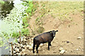
The River Lagan at the Newmill Bridge, Moira - July 2018(2)
See Image The upstream side of the bridge during the current long dry spell.
Image: © Albert Bridge
Taken: 13 Jul 2018
0.21 miles
2
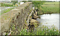
The Newmill Bridge near Moira
A three-arch stone bridge, with concrete-reinforced piers, carrying the Clarehill Road across the River Lagan. Built circa 1740/59. Listed and more information is available here http://www.doeni.gov.uk/niea/built/buildview?id=3248&js=true. Last seen in January 2006 Image
Image: © Albert Bridge
Taken: 30 Jun 2012
0.22 miles
3
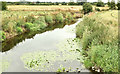
The River Lagan at the Newmill Bridge, Moira - July 2018(1)
The River Lagan, looking downstream, from the Newmill Bridge on the Clarehill Road, during the current long dry spell. There are water lilies growing and the riverbed is visible. For a seasonal comparison in water level see Image (September 2008).
Image: © Albert Bridge
Taken: 13 Jul 2018
0.22 miles