IMAGES TAKEN NEAR TO
Lany Road, CRAIGAVON, BT67 0NZ
Introduction
This page details the photographs taken nearby to Lany Road, BT67 0NZ by members of the Geograph project.
The Geograph project started in 2005 with the aim of publishing, organising and preserving representative images for every square kilometre of Great Britain, Ireland and the Isle of Man.

There are currently over 7.5m images from over14,400 individuals and you can help contribute to the project by visiting https://www.geograph.org.uk
Image Map
Images are licensed for reuse under creativecommons.org/licenses/by-sa/2.0
Notes
- Clicking on the map will re-center to the selected point.
- The higher the marker number, the further away the image location is from the centre of the postcode.
Image Listing (4 Images Found)
Images are licensed for reuse under creativecommons.org/licenses/by-sa/2.0
Image
Details
Distance
1
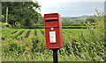
Letter box, Flatfield near Hillsborough
Post-mounted EIIR letter box (BT67 51) at the Lany Road end of Lavery’s Bridge Road. Subsequently replaced by a pressed-steel box Image
Image: © Albert Bridge
Taken: 23 Jun 2012
0.22 miles
2
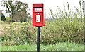
Postbox BT67 51, Flatfield near Hillsborough (April 2017)
A new pressed-steel postbox (BT67 51), close to the corner of Laverty’s Bridge Road and the Lany Road. It replaced this one Image
Image: © Albert Bridge
Taken: 18 Apr 2017
0.22 miles
3
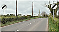
The Lany Road, Halliday's Bridge, Hillsborough/Moira (April 2017)
See Image The minor Lany Road, heading towards Moira, at the end of the short 40mph restriction through Halliday’s Bridge. For reference purposes the pumping station is just behind me to the left.
Image: © Albert Bridge
Taken: 18 Apr 2017
0.23 miles
4

Laverty's Bridge Road, Hillsborough/Moira (April 2017)
A minor road running south and south east, off the Lany Road (behind me) in the direction of Kilwarlin. Enhanced today by flowering whins and cherry blossom.
Image: © Albert Bridge
Taken: 18 Apr 2017
0.25 miles