IMAGES TAKEN NEAR TO
Broadwater Mews, CRAIGAVON, BT67 0FR
Introduction
This page details the photographs taken nearby to Broadwater Mews, BT67 0FR by members of the Geograph project.
The Geograph project started in 2005 with the aim of publishing, organising and preserving representative images for every square kilometre of Great Britain, Ireland and the Isle of Man.

There are currently over 7.5m images from over14,400 individuals and you can help contribute to the project by visiting https://www.geograph.org.uk
Image Map
Images are licensed for reuse under creativecommons.org/licenses/by-sa/2.0
Notes
- Clicking on the map will re-center to the selected point.
- The higher the marker number, the further away the image location is from the centre of the postcode.
Image Listing (10 Images Found)
Images are licensed for reuse under creativecommons.org/licenses/by-sa/2.0
Image
Details
Distance
1
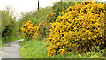
Whin bushes near Aghalee
One of the better displays of whins in 2013 – beside the towpath on the Soldierstown side of Aghalee village.
Image: © Albert Bridge
Taken: 12 May 2013
0.08 miles
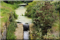
2
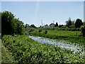
A walk by the Lagan Canal
Just outside Aghalee on the tow path
Image: © HENRY CLARK
Taken: 24 Jun 2009
0.10 miles
4
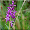
Orchid near Aghalee
A purple orchid, in a damp spot between the towpath and the old canal. It might be Orchis mascula https://en.wikipedia.org/wiki/Orchis_mascula.
Image: © Albert Bridge
Taken: 12 May 2013
0.13 miles
5
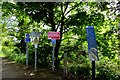
Do's and Don'ts
A galaxy of signs telling you everything you need to know whilst enjoying a leisurely walk or cycle along the old Lagan canal path near Aghalee. Located at the Aghalee end of the path.
Image: © Robert Ashby
Taken: 3 Jun 2015
0.13 miles
7
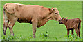
Cow and calf near Aghalee
A cow and a very young calf, in a field on the western side of the old canal, between Aghalee and Soldierstown.
Image: © Albert Bridge
Taken: 12 May 2013
0.15 miles
8
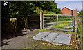
Gate and cattle grid, Aghalee
The Sprucefield – Moira section of the Lagan canal is now buried under the M1 Image The towpath remains from Moira Image via Soldierstown and the Broadwater Image to Aghalee. The gate and cattle grid are near the end, approaching Aghalee. Continue to Image
Image: © Albert Bridge
Taken: 10 Jul 2011
0.21 miles
9
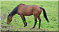
Horse, Aghalee
Grazing contentedly in a field at the start of the Lagan towpath.
Image: © Albert Bridge
Taken: 12 May 2013
0.21 miles
10
Disused Lagan canal. Aghalee (2)
Image: © Albert Bridge
Taken: 10 Jul 2011
0.25 miles