IMAGES TAKEN NEAR TO
Old Church Lane, CRAIGAVON, BT67 0EY
Introduction
This page details the photographs taken nearby to Old Church Lane, BT67 0EY by members of the Geograph project.
The Geograph project started in 2005 with the aim of publishing, organising and preserving representative images for every square kilometre of Great Britain, Ireland and the Isle of Man.

There are currently over 7.5m images from over14,400 individuals and you can help contribute to the project by visiting https://www.geograph.org.uk
Image Map
Images are licensed for reuse under creativecommons.org/licenses/by-sa/2.0
Notes
- Clicking on the map will re-center to the selected point.
- The higher the marker number, the further away the image location is from the centre of the postcode.
Image Listing (6 Images Found)
Images are licensed for reuse under creativecommons.org/licenses/by-sa/2.0
Image
Details
Distance
1
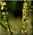
Agrimony near Agahalee
What, I think, is the yellow flower of agrimony Image growing beside the towpath on the Aghalee side of the old lock. See also Image
Image: © Albert Bridge
Taken: 10 Jul 2011
0.20 miles
2
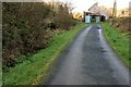
Towpath near Soldierstown
See Image A short section of the navigation and towpath pass through the NE corner of this square. This is the view towards Lough Neagh with the stop gates hidden by vegetation (middle top) and the bankranger’s house at top right.
Image: © Albert Bridge
Taken: 29 Nov 2007
0.21 miles
3
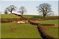
Trees and hedges near Aghalee
Trees, hedges and small undulations typical of the countryside in this area. The view is from the old canal towpath Image
Image: © Albert Bridge
Taken: 29 Nov 2007
0.22 miles
4
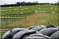
Farmland beside Old Church Lane
Sheep enjoy the last of the lush summer grass near Soldierstown. Bagged sileage for winter feed sits in the foreground.
Image: © Robert Ashby
Taken: 15 Oct 2014
0.23 miles
5
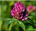
Red clover, Soldierstown near Moira
Red clover growing by the towpath, beside the Broadwater Image – not as common or frequent as the white variety Image
Image: © Albert Bridge
Taken: 10 Jul 2011
0.24 miles
6
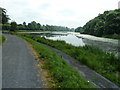
View of The Broadwater
Looking along The Broadwater towards Moira. The narrow mesh walkway is for angling. The Broadwater is a man-made feature dug in a natural valley to provide a sufficient of head of water to accommodate the navigation of the canal. Moira is said to be the only town in Ireland to straddle two counties, Co Armagh and Co Down, but as the River Lagan forms the border between Co Down and Co Antrim between Belfast and Lisburn both of these could also claim to do that.
Image: © Robert Ashby
Taken: 10 Jul 2013
0.25 miles