IMAGES TAKEN NEAR TO
Parknasilla Close, CRAIGAVON, BT67 0AW
Introduction
This page details the photographs taken nearby to Parknasilla Close, BT67 0AW by members of the Geograph project.
The Geograph project started in 2005 with the aim of publishing, organising and preserving representative images for every square kilometre of Great Britain, Ireland and the Isle of Man.

There are currently over 7.5m images from over14,400 individuals and you can help contribute to the project by visiting https://www.geograph.org.uk
Image Map
Images are licensed for reuse under creativecommons.org/licenses/by-sa/2.0
Notes
- Clicking on the map will re-center to the selected point.
- The higher the marker number, the further away the image location is from the centre of the postcode.
Image Listing (3 Images Found)
Images are licensed for reuse under creativecommons.org/licenses/by-sa/2.0
Image
Details
Distance
1
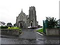
St Patrick's RC Church, Tiscallen, Aghagallon
Pictured along Aghalee Road
Image: © Kenneth Allen
Taken: 2 Jul 2013
0.10 miles
2
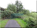
No Through Road
The path beside the old Lagan Canal near Aghagallon comes to an abrupt end at this metal fence. Unfortunately nobody thought to put a notice to this effect at Cranagh Bridge a mile or so back. Many an unwitting walker and cyclist has had a wasted, though scenic, journey here. The path was to have formed a link to the Broadwater at Aghalee via Goudy Bridge which has not been completed, possibly because of access issues. Part of the National Cycle Network's Route 9 to Oxford Island.
Image: © Robert Ashby
Taken: 22 Sep 2013
0.13 miles
3
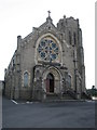
St Patrick's Church, Aghagallon
Roman Catholic Parish Church.
Image: © Brian Shaw
Taken: 20 Feb 2006
0.21 miles