IMAGES TAKEN NEAR TO
Russell Drive, CRAIGAVON, BT66 8HE
Introduction
This page details the photographs taken nearby to Russell Drive, BT66 8HE by members of the Geograph project.
The Geograph project started in 2005 with the aim of publishing, organising and preserving representative images for every square kilometre of Great Britain, Ireland and the Isle of Man.

There are currently over 7.5m images from over14,400 individuals and you can help contribute to the project by visiting https://www.geograph.org.uk
Image Map
Images are licensed for reuse under creativecommons.org/licenses/by-sa/2.0
Notes
- Clicking on the map will re-center to the selected point.
- The higher the marker number, the further away the image location is from the centre of the postcode.
Image Listing (25 Images Found)
Images are licensed for reuse under creativecommons.org/licenses/by-sa/2.0
Image
Details
Distance
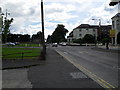
1
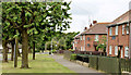
Russell Drive, Lurgan (June 2014)
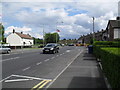
See Image (July 2009). Another part of the same street – opposite Mourne Road. This well-landscaped street, with numerous trees, might have been a Housing Trust estate. Further information welcome.
Image: © Albert Bridge
Taken: 23 Jun 2014
0.06 miles
2
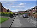
Gracey Drive, Mourneview
Gracey Drive in Lurgan's Mourneview Estate.
Image: © Dean Molyneaux
Taken: 15 Jul 2009
0.06 miles
3
Darling Avenue, Mourneview
Darling Avenue in Lurgan's Mourneview Estate.
Image: © Dean Molyneaux
Taken: 15 Jul 2009
0.09 miles
4
Brookehill, Mourneview
Brookehill in Lurgan's Mourneview Estate.
Image: © Dean Molyneaux
Taken: 15 Jul 2009
0.10 miles
5
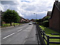
Russell Drive, Lurgan
Russell Drive in Lurgan.
Image: © Dean Molyneaux
Taken: 15 Jul 2009
0.15 miles
6
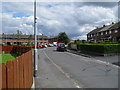
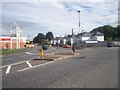
Mourne Road, Mourneview
Mourne Road in Lurgan's Mourneview Estate.
Image: © Dean Molyneaux
Taken: 15 Jul 2009
0.17 miles
7
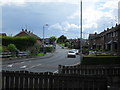
Waringstown Road / Gilford Road, Roundabout, Lurgan
Image: © P Flannagan
Taken: 19 Aug 2007
0.20 miles
8
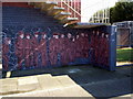
Mural, Union Street, Lurgan
The line-up at the workhouse. This Mural is dedicated to all the men, women and children who lived, worked and died here, in very harsh times, in the mid 1840's during the famine in Ireland. There were 403 inmates. The Workhouse was opened to the poor of Lurgan in 1841. It became Lurgan and Portadown District Hospital in 1929
Image: © P Flannagan
Taken: 13 Apr 2008
0.20 miles
9
Union Street and Tandragee Road
Union Street as it passes Sloan Street and Russell Drive - and becomes the Tandragee Road. The old Lurgan Hospital - now a care centre is on the right.
Image: © Dean Molyneaux
Taken: 15 Jul 2009
0.21 miles
10
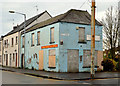
Former Union Street post office, Lurgan
The former Union Street post office, now closed and boarded up, at the corner of Hill Street (right). See also Image
Image: © Albert Bridge
Taken: 9 Nov 2012
0.21 miles