IMAGES TAKEN NEAR TO
Darling Avenue, CRAIGAVON, BT66 8HA
Introduction
This page details the photographs taken nearby to Darling Avenue, BT66 8HA by members of the Geograph project.
The Geograph project started in 2005 with the aim of publishing, organising and preserving representative images for every square kilometre of Great Britain, Ireland and the Isle of Man.

There are currently over 7.5m images from over14,400 individuals and you can help contribute to the project by visiting https://www.geograph.org.uk
Image Map
Images are licensed for reuse under creativecommons.org/licenses/by-sa/2.0
Notes
- Clicking on the map will re-center to the selected point.
- The higher the marker number, the further away the image location is from the centre of the postcode.
Image Listing (21 Images Found)
Images are licensed for reuse under creativecommons.org/licenses/by-sa/2.0
Image
Details
Distance
1
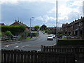
Mourne Road, Mourneview
Mourne Road in Lurgan's Mourneview Estate.
Image: © Dean Molyneaux
Taken: 15 Jul 2009
0.05 miles
2
Brookehill, Mourneview
Brookehill in Lurgan's Mourneview Estate.
Image: © Dean Molyneaux
Taken: 15 Jul 2009
0.06 miles
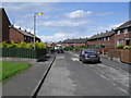
3
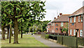
Darling Avenue, Mourneview
Darling Avenue in Lurgan's Mourneview Estate.
Image: © Dean Molyneaux
Taken: 15 Jul 2009
0.08 miles
4
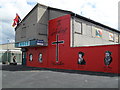
Mural of Protestant Reformation, Mourneview
A mural of the key players in the Protestant Reformation - at the shops on Mourne Road in Lurgan's Mourneview Estate. There was a loyalist paramilitary mural here originally.
Image: © Dean Molyneaux
Taken: 15 Jul 2009
0.10 miles
5
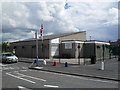
Mourneview Community Centre
Mourneview Community Centre on Pollock Drive in Lurgan's Mourneview Estate.
Image: © Dean Molyneaux
Taken: 15 Jul 2009
0.12 miles
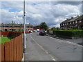
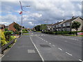
6

Pollock Drive, Mourneview
This is view from the western end of Pollock Drive, the main east-west thoroughfare in Lurgan's Mourneview Estate. The crowd can be explained by a football match at nearby Mourneview Park - home of Glenavon F.C.
The building to the right is the Dickson Primary School.
Image: © Dean Molyneaux
Taken: 20 Sep 2008
0.13 miles
7
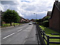
Gracey Drive, Mourneview
Gracey Drive in Lurgan's Mourneview Estate.
Image: © Dean Molyneaux
Taken: 15 Jul 2009
0.15 miles
8
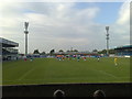
Mourneview Park, Lurgan
Home to Lurgan soccer side Glenavon Football Club. The stadium opened in the 1920s and has been added to greatly since. The terracing directly opposite ("The Hospital End") will soon be the next victim of the stadium regeneration.
Image: © Dean Molyneaux
Taken: 27 Sep 2008
0.16 miles
9
Pollock Drive, Mourneview (2)
Pollock Drive in Lurgan's Mourneview Estate.
Image: © Dean Molyneaux
Taken: 15 Jul 2009
0.17 miles
10
Russell Drive, Lurgan (June 2014)
See Image (July 2009). Another part of the same street – opposite Mourne Road. This well-landscaped street, with numerous trees, might have been a Housing Trust estate. Further information welcome.
Image: © Albert Bridge
Taken: 23 Jun 2014
0.19 miles