IMAGES TAKEN NEAR TO
Ferryview Close, CRAIGAVON, BT66 6TB
Introduction
This page details the photographs taken nearby to Ferryview Close, BT66 6TB by members of the Geograph project.
The Geograph project started in 2005 with the aim of publishing, organising and preserving representative images for every square kilometre of Great Britain, Ireland and the Isle of Man.

There are currently over 7.5m images from over14,400 individuals and you can help contribute to the project by visiting https://www.geograph.org.uk
Image Map
Images are licensed for reuse under creativecommons.org/licenses/by-sa/2.0
Notes
- Clicking on the map will re-center to the selected point.
- The higher the marker number, the further away the image location is from the centre of the postcode.
Image Listing (24 Images Found)
Images are licensed for reuse under creativecommons.org/licenses/by-sa/2.0
Image
Details
Distance
1
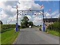
Orange Arch, Charlestown / Bannfoot
Pictured along Bannfoot Road
Image: © Kenneth Allen
Taken: 13 Jul 2011
0.05 miles
2
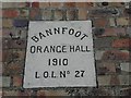
Bannfoot Orange Hall
Looking south from Bannfoot Road
Built in 1910, see close-up of plaque here Image]
Image: © Kenneth Allen
Taken: 13 Jul 2011
0.05 miles
3
Plaque, Bannfoot Orange Hall
Pictured here Image]
Image: © Kenneth Allen
Taken: 13 Jul 2011
0.07 miles
4
Looking back to Charlestown (Bannfoot)
An interesting wee place near Lough Neagh.
Image: © James Denham
Taken: 10 Feb 2009
0.07 miles
5
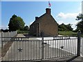
Bannfoot Orange Hall
It is located along Hill Lane
Image: © Kenneth Allen
Taken: 13 Jul 2011
0.08 miles
6
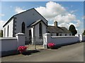
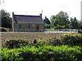
Methodist Church, Charlestown
It is located at Lough Lane
See close-up of plaque here Image]
Image: © Kenneth Allen
Taken: 13 Jul 2011
0.09 miles
7
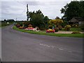
Ulster in Bloom
A lovely display at Charlestown village at the junction of Bannfoot Road and Lough Lane.
Image: © P Flannagan
Taken: 19 Aug 2012
0.10 miles
8
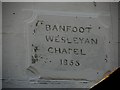
Plaque, Methodist Church, Charlestown
Reading, "Banfoot Wesleyan Chapel, 1855", it is pictured here
Note the spelling of Banfoot.
Image: © Kenneth Allen
Taken: 13 Jul 2011
0.11 miles
9
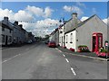
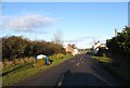
Charlestown or Bannfoot
The road sign says Charlestown, but on the map, it is indicated as Charlestown or Bannfoot. The locals tend to refer to it as the latter.
Image: © Kenneth Allen
Taken: 13 Jul 2011
0.12 miles
10
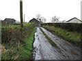
Lough Lane, Bannfoot
A mucky lane leading to the shore of Lough Neagh and the mouth of the (Upper) River Bann.
Image: © Dean Molyneaux
Taken: 22 Nov 2009
0.13 miles