IMAGES TAKEN NEAR TO
Lennys Road, CRAIGAVON, BT66 6QS
Introduction
This page details the photographs taken nearby to Lennys Road, BT66 6QS by members of the Geograph project.
The Geograph project started in 2005 with the aim of publishing, organising and preserving representative images for every square kilometre of Great Britain, Ireland and the Isle of Man.

There are currently over 7.5m images from over14,400 individuals and you can help contribute to the project by visiting https://www.geograph.org.uk
Image Map
Images are licensed for reuse under creativecommons.org/licenses/by-sa/2.0
Notes
- Clicking on the map will re-center to the selected point.
- The higher the marker number, the further away the image location is from the centre of the postcode.
Image Listing (6 Images Found)
Images are licensed for reuse under creativecommons.org/licenses/by-sa/2.0
Image
Details
Distance
1
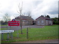
Primary School at Ardmore
Ardmore controlled primary school opened in 1931 on a large site, at the junction of Lennys Road and Church Road, in a rural setting near the southern shores of Lough Neagh, midway between Portadown and Lurgan. It was decided to close this school from 31st October 2006 as only 15 pupils were registered with the school.
Image: © P Flannagan
Taken: 12 Apr 2009
0.20 miles
2
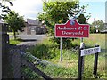
Ardmore Primary School, Derryadd
It is located along Church Road
Image: © Kenneth Allen
Taken: 13 Jul 2011
0.22 miles
3
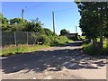
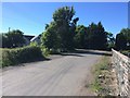
Lenny's Road, Derryadd
A minor road within the townland of Derryadd (Lurgan), linking the Ardmore Road with the main Lurgan-Derrytrasna road.
Image: © Dean Molyneaux
Taken: 17 Jun 2014
0.22 miles
4
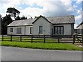
Building on Ardmore Road, Derryadd
It is probably the church hall
Image: © Kenneth Allen
Taken: 13 Jul 2011
0.23 miles
5
Church Road, Derryadd
As the name suggests, this minor road is just off Lenny's Road and runs alongside Ardmore [Anglican] Parish Church.
Image: © Dean Molyneaux
Taken: 17 Jun 2014
0.24 miles
6
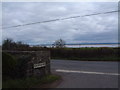
Church Road. Derryadd with Lough Neagh in view.
Church Road, Derryadd with Ardmore Church of Ireland to the left and Lough Neagh in view.
Image: © Steph
Taken: 12 Sep 2006
0.25 miles