IMAGES TAKEN NEAR TO
Hillcrest Mews, CRAIGAVON, BT65 5BH
Introduction
This page details the photographs taken nearby to Hillcrest Mews, BT65 5BH by members of the Geograph project.
The Geograph project started in 2005 with the aim of publishing, organising and preserving representative images for every square kilometre of Great Britain, Ireland and the Isle of Man.

There are currently over 7.5m images from over14,400 individuals and you can help contribute to the project by visiting https://www.geograph.org.uk
Image Map
Images are licensed for reuse under creativecommons.org/licenses/by-sa/2.0
Notes
- Clicking on the map will re-center to the selected point.
- The higher the marker number, the further away the image location is from the centre of the postcode.
Image Listing (3 Images Found)
Images are licensed for reuse under creativecommons.org/licenses/by-sa/2.0
Image
Details
Distance
1
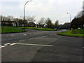
Drumgor Road, Craigavon
Drumgor Road is a busy thoroughfare which separates the Drumgor and Legahory neighbourhoods. It also carries a great deal of traffic between Lurgan and the central Craigavon area.
Image: © Dean Molyneaux
Taken: 30 Mar 2014
0.08 miles
2
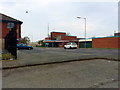
Health Centre, Legahory, Craigavon
This health centre serves the Brownlow sector of Craigavon and is located at the Legahory Centre.
Image: © Dean Molyneaux
Taken: 30 Mar 2014
0.18 miles
3
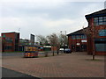
Legahory Centre
This is the front of the Legahory Centre, the main retail unit in the Brownlow sector of Craigavon. Within the building to right, there is a small mall with various shops and services, serving the various estates that surround it.
Image: © Dean Molyneaux
Taken: 30 Mar 2014
0.21 miles