IMAGES TAKEN NEAR TO
Scarva Road, CRAIGAVON, BT63 6BQ
Introduction
This page details the photographs taken nearby to Scarva Road, BT63 6BQ by members of the Geograph project.
The Geograph project started in 2005 with the aim of publishing, organising and preserving representative images for every square kilometre of Great Britain, Ireland and the Isle of Man.

There are currently over 7.5m images from over14,400 individuals and you can help contribute to the project by visiting https://www.geograph.org.uk
Image Map
Images are licensed for reuse under creativecommons.org/licenses/by-sa/2.0
Notes
- Clicking on the map will re-center to the selected point.
- The higher the marker number, the further away the image location is from the centre of the postcode.
Image Listing (14 Images Found)
Images are licensed for reuse under creativecommons.org/licenses/by-sa/2.0
Image
Details
Distance
1
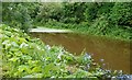
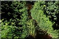
Old Newry Canal, Terryhoogan, Scarva
See Image Just south of the previous photo, the canal was exceptionally high and muddy.
Image: © Albert Bridge
Taken: 17 Aug 2008
0.05 miles
2
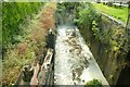
Terryhoogan lock near Scarva
See Image After heavy and persistent rain over the last 2-3 weeks followed by a deluge on 16 August there was excess water on the old Newry Canal. The effects can be seen as it pours through the derelict gates at Terryhoogan (Campbell’s) lock. The view is towards Newry. See also Image
Image: © Albert Bridge
Taken: 17 Aug 2008
0.06 miles
3
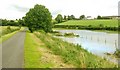
Flooding near Scarva
See Image The area close to the old canal floods easily but especially so after the exceptional rain over the last 2-3 weeks. The towpath is on the left, the canal is between the towpath and the fence (middle right). The heavy rain has caused the canal to overflow into the fields between the canal and the Scarva – Gilford road (right).
Image: © Albert Bridge
Taken: 17 Aug 2008
0.21 miles
4
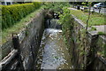
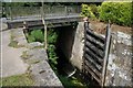
Lock no. 12 at Terryhoogan, Scarva, disused Newry Canal
The Newry canal connected Lough Neagh (via the River Bann) to the town of Newry and then through the Newry ship canal to Carlingford Lough and the Irish Sea. The canal opened in 1742, had become largely derelict by 1939 and was formally abandoned in 1949. It is now overgrown for most of its length and, despite much discussion, shows no sign of being re-opened for recreational use. The tow path has been restored for walkers and cyclists.
Image: © Albert Bridge
Taken: 19 May 2006
0.21 miles
5
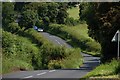
The Mullaghabrack Road near Scarva
The Mullaghbrack Road is an unclassified road running to the east of, and roughly parallel to, the Scarva-Gilford road. Just outside the drumlin belt, it is, nevertheless, winding and undulating. This is the view towards Gilford.
Image: © Albert Bridge
Taken: 20 Oct 2006
0.21 miles
6
Disused Newry canal at Terryhoogan, Scarva
See Image This is the canal (looking towards Lough Neagh) seen from the road bridge. The water level is measured in inches.
Image: © Albert Bridge
Taken: 1 Jul 2007
0.21 miles
7
Disused canal lock, Terryhoogan, Scarva
See Image This is the Lough Neagh end of the lock.
Image: © Albert Bridge
Taken: 1 Jul 2007
0.21 miles
8
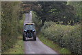
The Gilford Road near Scarva
Another road in drumlin country. The view is towards Gilford just past the Terryhoogan Road.
Image: © Albert Bridge
Taken: 28 Jul 2007
0.21 miles
9
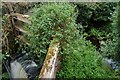
Old lock gates near Scarva
See Image A close view of the decaying gates at the Newry end of the lock. Image shows the gates after removal of the vegetation.
Image: © Albert Bridge
Taken: 8 Aug 2007
0.21 miles
10
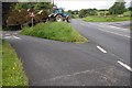
Crossroads near Scarva
The crossroads near Scarva with the Terryhoogan Road Image on the left, the Mullaghbrack Road Image on the right and the Scarva – Gilford road Image running ahead.
Image: © Albert Bridge
Taken: 16 Aug 2007
0.21 miles