IMAGES TAKEN NEAR TO
Cranny Road, CRAIGAVON, BT63 5SP
Introduction
This page details the photographs taken nearby to Cranny Road, BT63 5SP by members of the Geograph project.
The Geograph project started in 2005 with the aim of publishing, organising and preserving representative images for every square kilometre of Great Britain, Ireland and the Isle of Man.

There are currently over 7.5m images from over14,400 individuals and you can help contribute to the project by visiting https://www.geograph.org.uk
Image Map
Images are licensed for reuse under creativecommons.org/licenses/by-sa/2.0
Notes
- Clicking on the map will re-center to the selected point.
- The higher the marker number, the further away the image location is from the centre of the postcode.
Image Listing (2 Images Found)
Images are licensed for reuse under creativecommons.org/licenses/by-sa/2.0
Image
Details
Distance
1
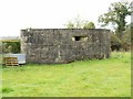
Pillbox, Cranny Road, Craigavon
Pillboxes were small concrete forts of various shapes and sizes, built as anti invasion defences during the second world war throughout Britain and Northern Ireland.
Image: © P Flannagan
Taken: 2 Apr 2008
0.09 miles
2
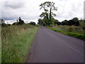
Cranny Road, travelling towards Bleary Village.
Image: © P Flannagan
Taken: 13 Aug 2007
0.13 miles