IMAGES TAKEN NEAR TO
Killycomain Road, CRAIGAVON, BT63 5BT
Introduction
This page details the photographs taken nearby to Killycomain Road, BT63 5BT by members of the Geograph project.
The Geograph project started in 2005 with the aim of publishing, organising and preserving representative images for every square kilometre of Great Britain, Ireland and the Isle of Man.

There are currently over 7.5m images from over14,400 individuals and you can help contribute to the project by visiting https://www.geograph.org.uk
Image Map
Images are licensed for reuse under creativecommons.org/licenses/by-sa/2.0
Notes
- Clicking on the map will re-center to the selected point.
- The higher the marker number, the further away the image location is from the centre of the postcode.
Image Listing (40 Images Found)
Images are licensed for reuse under creativecommons.org/licenses/by-sa/2.0
Image
Details
Distance
1
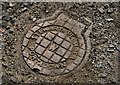
Stewarts access cover, Portadown
A small cover, marked “Stewart plumber Portadown” on the Killicomaine (“Killycomain” on the Google map) Road, opposite Portadown College.
Image: © Albert Bridge
Taken: 9 May 2012
0.03 miles
2
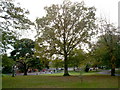
Eden Villa Park, Bachelors Walk, Portadown
Image: © P Flannagan
Taken: 18 Oct 2007
0.09 miles
3
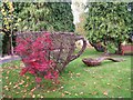
Cup and Spoon Sculpture, The Secret Garden, Eden Villa Park, Bachelors Walk, Portadown
Image: © P Flannagan
Taken: 18 Oct 2007
0.11 miles
4
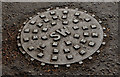
"SW" manhole cover, Portadown
SW “surface water” Image manhole cover on the Gilford Road opposite the Edenderry Day Centre. There is no maker’s name visible.
Image: © Albert Bridge
Taken: 9 May 2012
0.11 miles
5
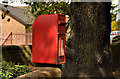
Letter box, Portadown
Post-mounted EIIR letter box (BT63 28) on the Gilford Road.
Image: © Albert Bridge
Taken: 9 May 2012
0.11 miles
6

Assembly election poster, Portadown - May 2016(3)
Carrickblacker Road. Sydney Anderson and Carla Lockhart (Democratic Unionist Party).
Image: © Albert Bridge
Taken: 5 May 2016
0.11 miles
7
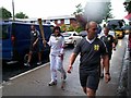
Olympic Torch
A brave woman carries the Olympic Torch on the Gilford Road Portadown N.Ireland on the 5th June 2012 on a very wet day.
Image: © Kenneth Flannagan
Taken: 5 Jun 2012
0.11 miles
8
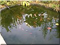
Fish Pond in The Secret Garden, Eden Villa Park, Bachelors Walk, Portadown
See Image
Image: © P Flannagan
Taken: 18 Oct 2007
0.12 miles
9
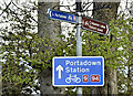
National Cycle Route signs, Portadown (May 2016)
National Cycle Network route (9 and 94) signs close to Bachelor’s Walk. The lower one has been turned through 180 degrees and now points in the wrong direction. The way to Portadown station is behind me.
Image: © Albert Bridge
Taken: 5 May 2016
0.12 miles
10
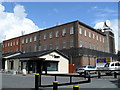
Telephone Exchange, Carrickblacker Road
The BT Telephone Exchange on Portadown's Carrickblacker Road.
Image: © Dean Molyneaux
Taken: 15 Jul 2009
0.13 miles