IMAGES TAKEN NEAR TO
Watson Street, CRAIGAVON, BT63 5AQ
Introduction
This page details the photographs taken nearby to Watson Street, BT63 5AQ by members of the Geograph project.
The Geograph project started in 2005 with the aim of publishing, organising and preserving representative images for every square kilometre of Great Britain, Ireland and the Isle of Man.

There are currently over 7.5m images from over14,400 individuals and you can help contribute to the project by visiting https://www.geograph.org.uk
Image Map
Images are licensed for reuse under creativecommons.org/licenses/by-sa/2.0
Notes
- Clicking on the map will re-center to the selected point.
- The higher the marker number, the further away the image location is from the centre of the postcode.
Image Listing (121 Images Found)
Images are licensed for reuse under creativecommons.org/licenses/by-sa/2.0
Image
Details
Distance
1
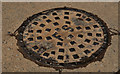
"FS" manhole cover, Portadown
A manhole cover, at the corner of Watson Street Image and Watson’s Lane marked “FS” which, I think, means “foul sewer”. There is no maker’s name visible.
Image: © Albert Bridge
Taken: 9 May 2012
0.02 miles
2
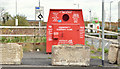
Recycling bin, Portadown (May 2016)
A clothing bin at Joseph Street.
Image: © Albert Bridge
Taken: 5 May 2016
0.04 miles
3

The new arch
On Bridge Street in Portadown
Image: © HENRY CLARK
Taken: 23 Jul 2008
0.04 miles
5
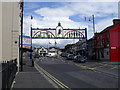
Orange Arch, Edenderry
The Orange Arch in Bridge Street at Edenderry.
Image: © Dean Molyneaux
Taken: 15 Jul 2009
0.05 miles
6
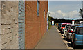
Watson Street, Portadown
The western side of a street off Bridge Street. It now leads to the Northway Image but previously led to the former Ulster Railway station Image (background).
The wall (left) was part of the Wade (Ireland) Limited factory (1947-90) which made ceramic insulators.
Image: © Albert Bridge
Taken: 9 May 2012
0.05 miles
7
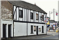
Former "Tavern Bar", Portadown (May 2016)
See Image (1986). The former “Tavern Bar” at the apex of Bridge Street (foreground) and the Carrickblacker Road. There is a “sold” patch on the “for sale” sign. The following description was included in the agents’ auction brochure (which included many other properties) “The property is a former licensed premises previously known as “The Tavern Bar” comprising of a two-storey end-terrace building with a single-storey flat roof extension to the side of the property. . . . . . . Note: We are advised that the property does not benefit from an intoxicating liquor licence.”
Image: © Albert Bridge
Taken: 5 May 2016
0.05 miles
8
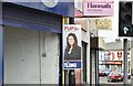
Assembly election poster, Portadown - May 2016(2)
Carrickblacker Road. Sophie Long (Progressive Unionist Party).
Image: © Albert Bridge
Taken: 5 May 2016
0.05 miles
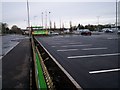
9
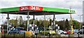
ASDA petrol station, Portadown (May 2016)
24 hour ASDA petrol station on the Joseph Street side of the supermarket Image (November 2012).
Image: © Albert Bridge
Taken: 5 May 2016
0.06 miles
10

Bridge Street, Portadown
Bridge Street (A27) in Portadown from the junction with Goban Street.
Image: © Rossographer
Taken: 17 Jun 2017
0.06 miles