IMAGES TAKEN NEAR TO
Old Scarva Road, CRAIGAVON, BT62 2ED
Introduction
This page details the photographs taken nearby to Old Scarva Road, BT62 2ED by members of the Geograph project.
The Geograph project started in 2005 with the aim of publishing, organising and preserving representative images for every square kilometre of Great Britain, Ireland and the Isle of Man.

There are currently over 7.5m images from over14,400 individuals and you can help contribute to the project by visiting https://www.geograph.org.uk
Image Map
Images are licensed for reuse under creativecommons.org/licenses/by-sa/2.0
Notes
- Clicking on the map will re-center to the selected point.
- The higher the marker number, the further away the image location is from the centre of the postcode.
Image Listing (4 Images Found)
Images are licensed for reuse under creativecommons.org/licenses/by-sa/2.0
Image
Details
Distance
1

Babbling brook
The Cusher River flowing under Glebe Hill Road at the edge of Tandragee.
Image: © Robert Ashby
Taken: 27 Jul 2016
0.09 miles
2

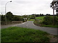
The Scarva Road, Tanderagee
This is the approach to Tanderagee (also “Tandragee”) from Scarva. The town is hidden around the bend, as is Whites – makers of “Speedicook” porridge. The small stone bridge (bottom right) carries the road over the River Cusher.
Image: © Albert Bridge
Taken: 9 Jun 2007
0.21 miles
3
Hare's Bridge
The Bridge is on the Newry Road on the outskirts of Tandragee
Image: © HENRY CLARK
Taken: 9 Sep 2007
0.21 miles
4
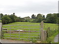
Tandragee Rovers Old Grounds
This is close to Hare's Bridge (Note a steep incline on the playing surface)
Image: © HENRY CLARK
Taken: 9 Sep 2007
0.21 miles