IMAGES TAKEN NEAR TO
Tullymore Road, ARMAGH, BT61 8NY
Introduction
This page details the photographs taken nearby to Tullymore Road, BT61 8NY by members of the Geograph project.
The Geograph project started in 2005 with the aim of publishing, organising and preserving representative images for every square kilometre of Great Britain, Ireland and the Isle of Man.

There are currently over 7.5m images from over14,400 individuals and you can help contribute to the project by visiting https://www.geograph.org.uk
Image Map
Images are licensed for reuse under creativecommons.org/licenses/by-sa/2.0
Notes
- Clicking on the map will re-center to the selected point.
- The higher the marker number, the further away the image location is from the centre of the postcode.
Image Listing (2 Images Found)
Images are licensed for reuse under creativecommons.org/licenses/by-sa/2.0
Image
Details
Distance
1
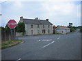
Red Lion Cross Roads
The main road is the B177 Loughgall (to the left) to Portadown road. Perhaps the boarded-up building opposite was the Red Lion!
Image: © Brian Shaw
Taken: 5 Jul 2006
0.24 miles
2
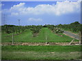
New Orchard
County Armagh is Ireland's Orchard County, and this part of it is full of orchards. In spite of the youth of these trees, they bear plenty of apples.
Image: © Brian Shaw
Taken: 5 Jul 2006
0.24 miles