IMAGES TAKEN NEAR TO
Haddington Gardens, BELFAST, BT6 0AN
Introduction
This page details the photographs taken nearby to Haddington Gardens, BT6 0AN by members of the Geograph project.
The Geograph project started in 2005 with the aim of publishing, organising and preserving representative images for every square kilometre of Great Britain, Ireland and the Isle of Man.

There are currently over 7.5m images from over14,400 individuals and you can help contribute to the project by visiting https://www.geograph.org.uk
Image Map
Images are licensed for reuse under creativecommons.org/licenses/by-sa/2.0
Notes
- Clicking on the map will re-center to the selected point.
- The higher the marker number, the further away the image location is from the centre of the postcode.
Image Listing (25 Images Found)
Images are licensed for reuse under creativecommons.org/licenses/by-sa/2.0
Image
Details
Distance
1

Assembly election poster, Cregagh Road, Belfast (April 2016)
Near Ardenlee Avenue. Ulster Unionist Party.
Image: © Albert Bridge
Taken: 7 Apr 2016
0.14 miles
2
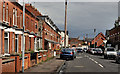
Dromore Street, Belfast
A street running from Earl Haig Gardens to the Cregagh Road (background). The 1908 street directory shows that it had a name but no houses. The 1910 edition had three houses and others in the course of erection. Previously seen in Image (July 2009). Shown as Earl Haig Gardens on the Google map.
Image: © Albert Bridge
Taken: 26 Apr 2012
0.14 miles
3
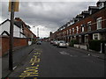
Dromore Street, Cregagh
This street - named after my own home town - runs along the side of Harding Memorial Primary School off the Cregagh Road.
Image: © Dean Molyneaux
Taken: 9 Jul 2009
0.16 miles
4
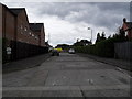
Former access to Graham Gardens, Cregagh
Prior to the construction of Ladas Drive in the 1940s, this was the access to Graham Gardens from the Cregagh Road - opposite Onslow Parade. Furthermore I believe this may have been a bus terminus at one stage. Nowadays it's used frequently by driving schools as a place for practising manoeuvres. Indeed a driving school car can be seen parked on the left.
Image: © Dean Molyneaux
Taken: 9 Jul 2009
0.16 miles
5
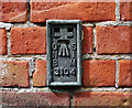
Flush Bracket, Belfast
Flush bracket located on Cregagh Congregational Church on Graham Gardens off Ladas Drive in Belfast. The bracket is located on a brick wall close to the main entrance.
The number on the bracket is OSNIBM 3104.
The mark is 10.75 metres above MSL.
A flush bracket is a type of bench mark set onto the face of a building. See also http://www.geograph.org.uk/search.php?i=11037856 for many other examples I have found.
Image: © Rossographer
Taken: 7 Jul 2010
0.18 miles
6
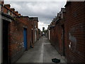
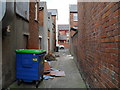
Entry between Dromore St and Reid St, Cregagh
This is the entry between the houses in Dromore Street and those in Reid Street, just off the Cregagh Road.
Image: © Dean Molyneaux
Taken: 9 Jul 2009
0.19 miles
7
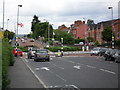
Bells Bridge, Cregagh Road
This is Bells Bridge Roundabout which was constructed in the 1940s in line with Ladas Drive and Mount Merrion Avenue - which at that time formed part of a ring road around the outside of the city. I presume at one point there was a bridge near here - as the Loop River passes nearby. This is also the municipal boundary between Belfast City and the Borough of Castlereagh.
Image: © Dean Molyneaux
Taken: 9 Jul 2009
0.19 miles
8
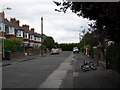
Graham Gardens, Cregagh
Graham Gardens sits just inside the city's municipal boundary and was constructed between 1936 and 1949. The long period can be explained by the effect of WWII - as numbers 17-23 are of a much more austere design. In the early 1990s, a mews development called "The Village Green" was constructed at the far end.
Image: © Dean Molyneaux
Taken: 9 Jul 2009
0.19 miles
9
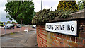
Ladas Drive sign, Belfast
An unusual sign, at the Cregagh Road end of Ladas Drive, beside the roundabout (middle left), which shows the old postal district number as “B6” rather than the standard “6”.
Image: © Albert Bridge
Taken: 24 May 2011
0.19 miles
10
Rear of premises on Cregagh Road - at Reid Street
This is the entry along the back of premises on the Cregagh Road between Dromore Street and Reid Street.
Image: © Dean Molyneaux
Taken: 9 Jul 2009
0.20 miles