IMAGES TAKEN NEAR TO
Lake Road, ARMAGH, BT60 3UP
Introduction
This page details the photographs taken nearby to Lake Road, BT60 3UP by members of the Geograph project.
The Geograph project started in 2005 with the aim of publishing, organising and preserving representative images for every square kilometre of Great Britain, Ireland and the Isle of Man.

There are currently over 7.5m images from over14,400 individuals and you can help contribute to the project by visiting https://www.geograph.org.uk
Image Map
Images are licensed for reuse under creativecommons.org/licenses/by-sa/2.0
Notes
- Clicking on the map will re-center to the selected point.
- The higher the marker number, the further away the image location is from the centre of the postcode.
Image Listing (7 Images Found)
Images are licensed for reuse under creativecommons.org/licenses/by-sa/2.0
Image
Details
Distance
2
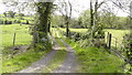
Farm Lane
This farm lane leads from Castleblayney Road to Clea Lake. It leads down over the Clea River and the course of the old Keady to Castleblayney railway. For more information see https://www.geograph.ie/photo/6904369 and https://www.geograph.ie/photo/6904373
Image: © Sean Davis
Taken: 20 May 2020
0.18 miles
3

Clea River and Old Railway from Bridge
The Clea River (aka Clay River) and course of the old Keady to Castleblayney railway line from a bridge on a farm lane which runs from Castleblayney Road to Clea Lake. You can see the bridge at https://www.geograph.ie/photo/6904369 and also read more about the railway at https://en.wikipedia.org/wiki/Castleblayney,_Keady_and_Armagh_Railway
Image: © Sean Davis
Taken: 20 May 2020
0.18 miles
4
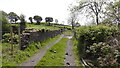
Lane over Clea River at Crossdened
This farm lane leads from Castleblayney Road to the source of the Clea River at Clea Lake (aka Clay Lake). The bridge in the photo crosses the Clea River and the disused Keady to Castleblayney railway. You can see the view down from the bridge at https://www.geograph.ie/photo/6904373 and also read more about the railway at https://en.wikipedia.org/wiki/Castleblayney,_Keady_and_Armagh_Railway
Image: © Sean Davis
Taken: 20 May 2020
0.19 miles
5
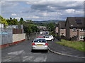
Church Street, Keady
Looking towards the village.
Image: © Dean Molyneaux
Taken: 19 Jul 2009
0.21 miles
6
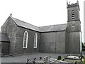
St Matthew's Church of Ireland, Keady
See close-up of plaque here Image]
Image: © Kenneth Allen
Taken: 28 Aug 2013
0.23 miles
7
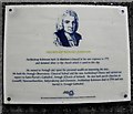
Plaque, St Matthew's Church
The following text is included in the description, "ARCHBISHOP RICHARD ROBINSON
Archbishop Robinson built St Matthew's Church'at'his own expense in 1775 and donated silver to the church which is used to this day. He moved to Armagh and spent his personal wealth on improving the area. He built the Armagh Observatory. Classical School and the new Archbishops House and carried out repairs to Saint Patrick's Cathedral, Armagh (Church of Ireland). He also built parish churches at Lisnadill, Newtownhamilton, Ballymakenny and Clonmore. Archbishop Robinson died in 1794 and was buried in Armagh Cathedral."
Pictured here Image]
Image: © Kenneth Allen
Taken: 28 Aug 2013
0.24 miles