IMAGES TAKEN NEAR TO
Rockvale, ARMAGH, BT60 3JG
Introduction
This page details the photographs taken nearby to Rockvale, BT60 3JG by members of the Geograph project.
The Geograph project started in 2005 with the aim of publishing, organising and preserving representative images for every square kilometre of Great Britain, Ireland and the Isle of Man.

There are currently over 7.5m images from over14,400 individuals and you can help contribute to the project by visiting https://www.geograph.org.uk
Image Map
Images are licensed for reuse under creativecommons.org/licenses/by-sa/2.0
Notes
- Clicking on the map will re-center to the selected point.
- The higher the marker number, the further away the image location is from the centre of the postcode.
Image Listing (5 Images Found)
Images are licensed for reuse under creativecommons.org/licenses/by-sa/2.0
Image
Details
Distance
1
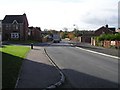
Housing estate at Demesne Park
These houses off Rock Road were photographed from the Keady Road
Image: © Eric Jones
Taken: 2 Jun 2016
0.09 miles
2
Rock Road, Armagh
Lots of new developments on the city out-skirts.
Image: © Kenneth Allen
Taken: 7 Nov 2007
0.15 miles
3
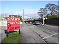
Start of new housing development at Armagh
This is just south of Armagh City on the A29 towards Keady. This is the site of the now closed and demolished Armagh Integrated College.
Image: © Sean Davis
Taken: 1 May 2020
0.20 miles
4
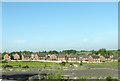
Armagh, County Armagh
The Cathedral can be seen in the distance
Image: © Kenneth Allen
Taken: 7 Nov 2007
0.23 miles
5
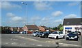
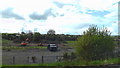
Car park serving a unit of businesses at the junction of Keady Road and Rock Road
Image: © Eric Jones
Taken: 3 Jun 2016
0.25 miles