IMAGES TAKEN NEAR TO
Upper Darkley Road, ARMAGH, BT60 3BS
Introduction
This page details the photographs taken nearby to Upper Darkley Road, BT60 3BS by members of the Geograph project.
The Geograph project started in 2005 with the aim of publishing, organising and preserving representative images for every square kilometre of Great Britain, Ireland and the Isle of Man.

There are currently over 7.5m images from over14,400 individuals and you can help contribute to the project by visiting https://www.geograph.org.uk
Image Map
Images are licensed for reuse under creativecommons.org/licenses/by-sa/2.0
Notes
- Clicking on the map will re-center to the selected point.
- The higher the marker number, the further away the image location is from the centre of the postcode.
Image Listing (7 Images Found)
Images are licensed for reuse under creativecommons.org/licenses/by-sa/2.0
Image
Details
Distance
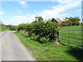
1
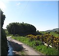
Sheugh below the Upper Darkley Road
This drains towards Tullynawood Lake.
Image: © Eric Jones
Taken: 2 Jun 2016
0.05 miles
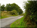
3
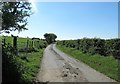
Country lane running in the direction of The Border
The road is not named on Google Street View, but I believe it to be Upper Darkley Road. The surface of the road suggests that cattle are regularly moved along it between field and milking parlour.
Image: © Eric Jones
Taken: 2 Jun 2016
0.11 miles
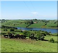
4
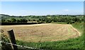
Harvested hay field below the Upper Darkley Road
Image: © Eric Jones
Taken: 2 Jun 2016
0.17 miles
7
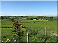
Upper Darkley Road, Aughnagurgan
Looking south in Aughnagurgan townland.
Image: © Dean Molyneaux
Taken: 14 Aug 2009
0.24 miles