IMAGES TAKEN NEAR TO
Tullynawood Road, ARMAGH, BT60 3BR
Introduction
This page details the photographs taken nearby to Tullynawood Road, BT60 3BR by members of the Geograph project.
The Geograph project started in 2005 with the aim of publishing, organising and preserving representative images for every square kilometre of Great Britain, Ireland and the Isle of Man.

There are currently over 7.5m images from over14,400 individuals and you can help contribute to the project by visiting https://www.geograph.org.uk
Image Map
Images are licensed for reuse under creativecommons.org/licenses/by-sa/2.0
Notes
- Clicking on the map will re-center to the selected point.
- The higher the marker number, the further away the image location is from the centre of the postcode.
Image Listing (20 Images Found)
Images are licensed for reuse under creativecommons.org/licenses/by-sa/2.0
Image
Details
Distance
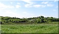
1
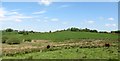
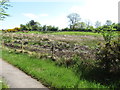
Wetland hollow surrounded by drumlins
This land is used for summer grazing while the drier drumlin slope land is used for hay making.
Image: © Eric Jones
Taken: 2 Jun 2016
0.09 miles
2
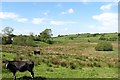
Inter-drumlin wetland hollow on the north side of Tullynawood Road
Image: © Eric Jones
Taken: 2 Jun 2016
0.09 miles
4
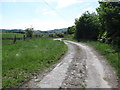
View south through sweeping curves along Tullynawood Road
Image: © Eric Jones
Taken: 2 Jun 2016
0.10 miles
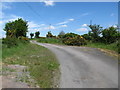
5
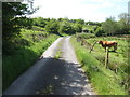
View west in the direction of the Border along Tullynawood Road
Image: © Eric Jones
Taken: 2 Jun 2016
0.10 miles
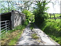
8
Derelict homestead between two drumlins on the Tullynawood Road
This farm house and outbuildings adjoin an inter-drumlin wet land hollow.
Image: © Eric Jones
Taken: 2 Jun 2016
0.12 miles
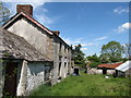
9
Derelict Border farmhouse on Tullynawood Road
Image: © Eric Jones
Taken: 2 Jun 2016
0.12 miles
10
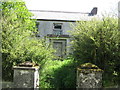
A derelict house near the Border
An adjoining house, also facing Tullynawood Road, is likewise derelict.
Image]
Image: © Eric Jones
Taken: 2 Jun 2016
0.13 miles