IMAGES TAKEN NEAR TO
Annvale Crescent, ARMAGH, BT60 2SH
Introduction
This page details the photographs taken nearby to Annvale Crescent, BT60 2SH by members of the Geograph project.
The Geograph project started in 2005 with the aim of publishing, organising and preserving representative images for every square kilometre of Great Britain, Ireland and the Isle of Man.

There are currently over 7.5m images from over14,400 individuals and you can help contribute to the project by visiting https://www.geograph.org.uk
Image Map
Images are licensed for reuse under creativecommons.org/licenses/by-sa/2.0
Notes
- Clicking on the map will re-center to the selected point.
- The higher the marker number, the further away the image location is from the centre of the postcode.
Image Listing (47 Images Found)
Images are licensed for reuse under creativecommons.org/licenses/by-sa/2.0
Image
Details
Distance
2
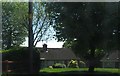
Entrance to Keady Glen Park
The entrance to Keady Glen Park at Annvale from the Glen Road.
Image: © Sean Davis
Taken: 3 Aug 2021
0.03 miles
3
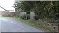
Tassagh Road past Annvale Gardens
View along the Tassagh Road past Annvale Gardens at Keady.
Image: © Sean Davis
Taken: 4 Mar 2020
0.04 miles
4
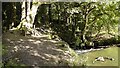
Footbridge over Clea River in Annvale Glen
Looking down at the footbridge over the River Clea at Annvale Glen, viewed from the footpath that leads down from Annvale Crescent in Keady, Armagh.
Image: © Sean Davis
Taken: 17 Sep 2017
0.05 miles
5
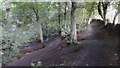
River from Top Path at Annvale Glen
Clea River and river path from the top path in Annvale Glen, Keady, Armagh.
Image: © Sean Davis
Taken: 17 Sep 2017
0.06 miles
6
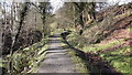
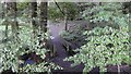
Level Path and Mill Race
The level path and old mill race through Annvale Glen at Keady. This glen was used for training exercises by American Soldiers during World War 2.
Image: © Sean Davis
Taken: 4 Mar 2020
0.07 miles
7
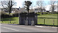
Bus Shelter at Annvale
Old bus shelter on the Tassagh Road at Annvale. This is for the 69 service from Keady to Armagh via Tassagh. Behind it is Annvale Heights and to the right-centre you can make out the embankment of the now abandoned Keady to Armagh Railway. The railway opened in 1909 and closed in 1957.
Image: © Sean Davis
Taken: 4 Mar 2020
0.08 miles
8
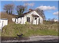
Derelict House
Derelict house on the Tassagh Road just outside Keady.
Image: © Sean Davis
Taken: 4 Mar 2020
0.09 miles
9
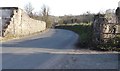
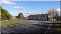
Annvale Road after Annvale Gardens
Annvale Road immediately south of Annvale Gardens. The old wall on the left was once part of the huge Annvale Mills Complex. The road is popular with walkers, but there is no pavement for the next 400 yards.
Image: © Sean Davis
Taken: 22 Mar 2020
0.09 miles
10
Bench and Waterfall Annvale Glen
The old wooden bench by the small waterfall in Annvale Glen, Keady Armagh. This was taken just before the bench was destroyed by vandals. It had sat here for over 50 years.
Image: © Sean Davis
Taken: 25 Sep 2017
0.09 miles