IMAGES TAKEN NEAR TO
Annvale Road, ARMAGH, BT60 2NY
Introduction
This page details the photographs taken nearby to Annvale Road, BT60 2NY by members of the Geograph project.
The Geograph project started in 2005 with the aim of publishing, organising and preserving representative images for every square kilometre of Great Britain, Ireland and the Isle of Man.

There are currently over 7.5m images from over14,400 individuals and you can help contribute to the project by visiting https://www.geograph.org.uk
Image Map
Images are licensed for reuse under creativecommons.org/licenses/by-sa/2.0
Notes
- Clicking on the map will re-center to the selected point.
- The higher the marker number, the further away the image location is from the centre of the postcode.
Image Listing (2 Images Found)
Images are licensed for reuse under creativecommons.org/licenses/by-sa/2.0
Image
Details
Distance
1
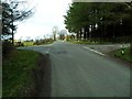
Tottens Crossroads, Armaghbrague
The name of this crossroads appears as early on as the 1830s O.S. Series - at that time the road [from left to right] was the main road from Keady to Newtownhamilton. This has long since been rerouted as the A29, a few hundred yards to the south.
The road running straight ahead is the Armaghbrague Road - which makes a link between Altnamachin and Armagh.
Townland of Armaghbrague.
Image: © Dean Molyneaux
Taken: 21 Mar 2010
0.12 miles
2
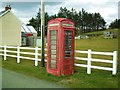
Telephone Box at Armaghbrague
This ageing call box sits on the Armaghbrague Road, just north of Tottens Crossroads - Image It is connected to the Keady telephone exchange - which is about four miles away as the crow flies.
Like many other rural boxes, it no longer accepts coins thus a payment card is required to use it.
Image: © Dean Molyneaux
Taken: 21 Mar 2010
0.12 miles