IMAGES TAKEN NEAR TO
Knoxs Hill, ARMAGH, BT60 2HP
Introduction
This page details the photographs taken nearby to Knoxs Hill, BT60 2HP by members of the Geograph project.
The Geograph project started in 2005 with the aim of publishing, organising and preserving representative images for every square kilometre of Great Britain, Ireland and the Isle of Man.

There are currently over 7.5m images from over14,400 individuals and you can help contribute to the project by visiting https://www.geograph.org.uk
Image Map
Images are licensed for reuse under creativecommons.org/licenses/by-sa/2.0
Notes
- Clicking on the map will re-center to the selected point.
- The higher the marker number, the further away the image location is from the centre of the postcode.
Image Listing (6 Images Found)
Images are licensed for reuse under creativecommons.org/licenses/by-sa/2.0
Image
Details
Distance
1
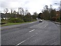
A28 Newry Road, Armagh
Heading south-east via Market Hill to Newry
Image: © Kenneth Allen
Taken: 28 Nov 2007
0.15 miles
2
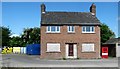
Boarded-up house on the A28 at Armagh
This is a part of a development site which also includes what appears to be a former service station.
Image: © Eric Jones
Taken: 3 Jun 2016
0.16 miles
3
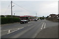
The A28 Markethill Road (4)
Facilities at the top of the hill.
Image: © Robert Ashby
Taken: 11 May 2016
0.20 miles
4

A28 at Armagh
Just a short distance northwards to the city centre
Image: © Kenneth Allen
Taken: 28 Nov 2007
0.21 miles
5
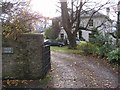
Linden House, Armagh
A period house located to the south of the city
Image: © Kenneth Allen
Taken: 28 Nov 2007
0.21 miles
6
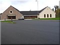
Armagh Baptist Church
It is located off the Newry Road and at the south side of the city.
Image: © Kenneth Allen
Taken: 28 Nov 2007
0.21 miles