IMAGES TAKEN NEAR TO
Keady Street, ARMAGH, BT60 1PN
Introduction
This page details the photographs taken nearby to Keady Street, BT60 1PN by members of the Geograph project.
The Geograph project started in 2005 with the aim of publishing, organising and preserving representative images for every square kilometre of Great Britain, Ireland and the Isle of Man.

There are currently over 7.5m images from over14,400 individuals and you can help contribute to the project by visiting https://www.geograph.org.uk
Image Map
Images are licensed for reuse under creativecommons.org/licenses/by-sa/2.0
Notes
- Clicking on the map will re-center to the selected point.
- The higher the marker number, the further away the image location is from the centre of the postcode.
Image Listing (41 Images Found)
Images are licensed for reuse under creativecommons.org/licenses/by-sa/2.0
Image
Details
Distance
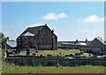
1
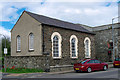
Markethill Methodist Church
Methodist church located on Keady Street in Markethill.
"The Markethill Methodist chapel, situated near the western extremity of the town on the Keady road, is a plain rectangular building of unhewn stone, slated and in good order, built in 1833. Length 49 feet, breadth 24 and a half feet." (source: Ordnance Survey Memoirs 1835-38)
Image: © Rossographer
Taken: 12 Apr 2012
0.02 miles
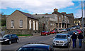
2
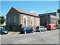
Methodist Church in Keady Street, Markethill
Image: © Eric Jones
Taken: 1 Jun 2016
0.02 miles
3
Geddis Square Shopping Centre, Markethill
Image: © Eric Jones
Taken: 1 Jun 2016
0.03 miles
4
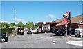
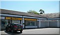
Today Store and Star Filling Station
This is located on the B3 immediately north of the Coolmillish Road mini roundabout.
Image: © Eric Jones
Taken: 1 Jun 2016
0.03 miles
5
Keady Street, Markethill
Keady Street in the village of Markethill (marked as the Coolmillish Road on Google).
Image: © Rossographer
Taken: 12 Apr 2012
0.04 miles
6
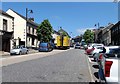
View north along the B78 at Markethill
Although Markethill is by-passed by the A28 (Armagh to Newry road) traffic congestion remains a feature of the town centre.
Image: © Eric Jones
Taken: 1 Jun 2016
0.06 miles
7

View eastwards towards the centre of Markethill along Coolmillish Road
Image: © Eric Jones
Taken: 1 Jun 2016
0.06 miles
8
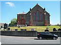
Markethill's First Presbyterian Church
Presbyterianism, in this predominantly Protestant and Unionist market town, dates back to the late seventeenth century. The present church building was consecrated in 1900.
Image: © Eric Jones
Taken: 1 Jun 2016
0.06 miles
9
The First Presbyterian Church, Markethill
Presbyterianism, in this predominantly Protestant and Unionist market town, dates back to the late seventeenth century. The present church building was consecrated in 1900.
Image: © Eric Jones
Taken: 1 Jun 2016
0.06 miles
10
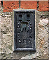
Flush Bracket, Markethill
Flush bracket bench mark located in the northern face of First Markethill Presbyterian Church Image
The number on the bracket is OSNIBM 3110.
The mark is 95.95 metres above MSL.
Image: © Rossographer
Taken: 12 Apr 2012
0.06 miles