IMAGES TAKEN NEAR TO
Ardcarn Park, BELFAST, BT5 7RQ
Introduction
This page details the photographs taken nearby to Ardcarn Park, BT5 7RQ by members of the Geograph project.
The Geograph project started in 2005 with the aim of publishing, organising and preserving representative images for every square kilometre of Great Britain, Ireland and the Isle of Man.

There are currently over 7.5m images from over14,400 individuals and you can help contribute to the project by visiting https://www.geograph.org.uk
Image Map
Images are licensed for reuse under creativecommons.org/licenses/by-sa/2.0
Notes
- Clicking on the map will re-center to the selected point.
- The higher the marker number, the further away the image location is from the centre of the postcode.
Image Listing (48 Images Found)
Images are licensed for reuse under creativecommons.org/licenses/by-sa/2.0
Image
Details
Distance
1
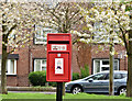
Postbox BT5 433, Ardcarn, Belfast (April 2017)
A new pressed-steel postbox (BT5 433) at Ardcarn Drive.
Image: © Albert Bridge
Taken: 28 Apr 2017
0.03 miles
2
Carnet House, Belfast - September 2017(2)
The block from the south.
Image: © Albert Bridge
Taken: 29 Sep 2017
0.04 miles
3
Carnet House, Belfast (June 2017)
Renovation work continuing. More than half of the block has received major external alterations.
Image: © Albert Bridge
Taken: 12 Jun 2017
0.04 miles
4
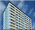
Carnet House, Belfast - September 2017(1)
Most of the renovation work is complete although there were a few men still working lower down. This is the eastern side, from beside the garages, at Ardcarn Park. Image shows the block, in August 2011, long before renovation.
Image: © Albert Bridge
Taken: 29 Sep 2017
0.05 miles
5
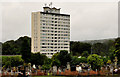
Carnet House, Belfast (3)
See Image Possibly the best-known view – from the Upper Newtownards Road, near the Stoney Road.
Image: © Albert Bridge
Taken: 2 Aug 2011
0.05 miles
6
Carnet House, Belfast (2)
Image: © Albert Bridge
Taken: 2 Aug 2011
0.05 miles
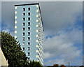
7
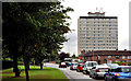
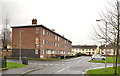
Carnet House, Belfast (1)
A 15-storey block, at the Upper Newtownards Road (northern) end of the Ardcarn estate, between Belfast and Dundonald. Built by the Northern Ireland Housing Trust in the 1950’s and the only tall building in an estate of conventional houses. The best view (for photographic purposes) is this one from Dundonald Cemetery. Image shows the block after major renovation.
Image: © Albert Bridge
Taken: 2 Aug 2011
0.05 miles
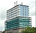
8
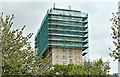
Carnet House, Belfast (April 2017)
Carnet House, enclosed by scaffolding and mesh, is undergoing a major renovation.
Image: © Albert Bridge
Taken: 28 Apr 2017
0.05 miles
9
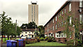
Ardcarn Green, Belfast
This view shows what might be called a “period piece” example of design in social housing back in the 1950/60’s. The Ardcarn estate was a medium-sized greenfield development which extended the existing limit of developed east Belfast. Many of the houses were rendered, there was the obligatory tower block Image and flat-roofed accommodation which can also be seen at Cregagh Image and Annadale Image
Image: © Albert Bridge
Taken: 14 Feb 2014
0.05 miles
10
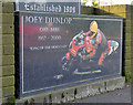
Joey Dunlop memorial, Belfast
A memorial, outside a monumental sculptor, on the Upper Newtownards Road near Ardcarn, commemorating the racing motorcyclist Joey Dunlop http://www.geograph.org.uk/search.php?i=44841926 and http://en.wikipedia.org/wiki/Joey_Dunlop.
Image: © Albert Bridge
Taken: 1 Nov 2013
0.08 miles