IMAGES TAKEN NEAR TO
Shandon Heights, Lower Braniel Road, BELFAST, BT5 7NW
Introduction
This page details the photographs taken nearby to Shandon Heights, Lower Braniel Road, BT5 7NW by members of the Geograph project.
The Geograph project started in 2005 with the aim of publishing, organising and preserving representative images for every square kilometre of Great Britain, Ireland and the Isle of Man.

There are currently over 7.5m images from over14,400 individuals and you can help contribute to the project by visiting https://www.geograph.org.uk
Image Map
Images are licensed for reuse under creativecommons.org/licenses/by-sa/2.0
Notes
- Clicking on the map will re-center to the selected point.
- The higher the marker number, the further away the image location is from the centre of the postcode.
Image Listing (2 Images Found)
Images are licensed for reuse under creativecommons.org/licenses/by-sa/2.0
Image
Details
Distance
1
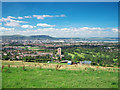
Belfast from Braniel
A view over Belfast from the Middle Braniel Road. Braniel and Shandon golf course in the foreground with central Belfast beyond - note prominent features such as the shipyard cranes. The hills of County Antrim can be seen in the distance.
Image: © Rossographer
Taken: 30 Aug 2010
0.18 miles
2
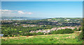
East Belfast from Braniel
A view over east Belfast from the Middle Braniel Road. Braniel and Tullycarnet can be seen in the foreground; the Holywood hills and Parliament Buildings can be seen beyond.
Image: © Rossographer
Taken: 30 Aug 2010
0.21 miles