IMAGES TAKEN NEAR TO
Thornhill Drive, BELFAST, BT5 7AW
Introduction
This page details the photographs taken nearby to Thornhill Drive, BT5 7AW by members of the Geograph project.
The Geograph project started in 2005 with the aim of publishing, organising and preserving representative images for every square kilometre of Great Britain, Ireland and the Isle of Man.

There are currently over 7.5m images from over14,400 individuals and you can help contribute to the project by visiting https://www.geograph.org.uk
Image Map
Images are licensed for reuse under creativecommons.org/licenses/by-sa/2.0
Notes
- Clicking on the map will re-center to the selected point.
- The higher the marker number, the further away the image location is from the centre of the postcode.
Image Listing (74 Images Found)
Images are licensed for reuse under creativecommons.org/licenses/by-sa/2.0
Image
Details
Distance
1
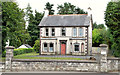
No 529 Upper Newtownards Road, Belfast
A vacant house, on the Upper Newtownards Road, almost opposite Stormont Park.
Image: © Albert Bridge
Taken: 29 Aug 2013
0.06 miles
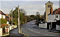
2
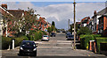
Thornhill Drive, Belfast
A concrete-paved street of detached houses, running from here, on Barnett's Road, to the Upper Newtownards Road, near Stormont.
Image: © Albert Bridge
Taken: 5 Sep 2011
0.06 miles
3
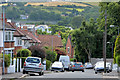
Thornhill Park, Belfast (2013)
See Image (December 2011). The view in the other direction, towards the Castlereagh Hills. The entrance to Thornhill Parade Image is at the bottom right.
Image: © Albert Bridge
Taken: 12 Aug 2013
0.07 miles
4
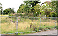
Vacant site, Barnett's Road, Belfast (2013)
The site of a house, on the northern side of Barnett’s Road between Thornhill Drive and Thornhill Grove, cleared for a development which has still to happen.
Image: © Albert Bridge
Taken: 29 Aug 2013
0.08 miles
5
Thornhill Park, Belfast (2011)
The Upper Newtownards Road end of a suburban road running from Barnett’s Road Image The Castlehill Road Image is straight ahead. Stormont Presbyterian church Image is on the right. Continue to Image (August 2013).
Image: © Albert Bridge
Taken: 13 Dec 2011
0.09 miles
6

Development site, 57 Barnett's Road, Belfast (2013-2)
The Barnett’s Road frontage.
Image: © Albert Bridge
Taken: 29 Aug 2013
0.09 miles
7
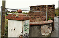
Old gate pillar, Belfast
An old gate pillar at 57 Barnett’s Road.
Image: © Albert Bridge
Taken: 10 Oct 2011
0.09 miles
8
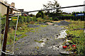
Development site, 57 Barnett's Road, Belfast (2011)
A vacant site, close to Barnett’s Crescent and Thornhill Drive Image
Image: © Albert Bridge
Taken: 10 Oct 2011
0.09 miles
9
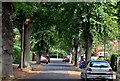
Knockburn Park, Belfast
A tree-lined street, on the southern side of the Upper Newtownards Road, which developed over many years in the early part of the 20th century. Given its proximity to Parliament Buildings Image it’s not surprising to discover that the 1943 street directory shows the editor of the Stormont Hansard as a resident.
Image: © Albert Bridge
Taken: 12 Aug 2013
0.09 miles
10
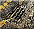
Stewart's grating cover, Belfast (3)
A Stewart’s Sandy Row Foundry grating cover http://www.geograph.org.uk/search.php?i=27184630 at the Upper Newtownards Road end of Thornhill Park Image
Image: © Albert Bridge
Taken: 13 Dec 2011
0.09 miles