IMAGES TAKEN NEAR TO
Ballybogy Road, BUSHMILLS, BT57 8UQ
Introduction
This page details the photographs taken nearby to Ballybogy Road, BT57 8UQ by members of the Geograph project.
The Geograph project started in 2005 with the aim of publishing, organising and preserving representative images for every square kilometre of Great Britain, Ireland and the Isle of Man.

There are currently over 7.5m images from over14,400 individuals and you can help contribute to the project by visiting https://www.geograph.org.uk
Image Map
Images are licensed for reuse under creativecommons.org/licenses/by-sa/2.0
Notes
- Clicking on the map will re-center to the selected point.
- The higher the marker number, the further away the image location is from the centre of the postcode.
Image Listing (7 Images Found)
Images are licensed for reuse under creativecommons.org/licenses/by-sa/2.0
Image
Details
Distance
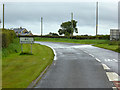
1
Priestland Road
It is in the townland of Ballyhome
Image: © Kenneth Allen
Taken: 28 May 2006
0.13 miles
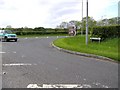
2
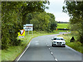
Direction sign on Ballybogey Road at the junction with
Ballybogey, also spelt Ballybogy, is derived from the Irish Baile Bogaigh meaning "boggy townland"
Image: © Eric Jones
Taken: 9 Aug 2011
0.14 miles
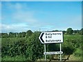
4
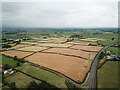
Golden Crops in North Antrim
Looking south east from junction of B62 & B17 in North Antrim.
Image: © KS
Taken: 2 Aug 2021
0.17 miles
5
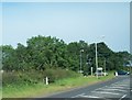
The junction of Ballybogy Road and Cloyfin Road
Image: © Eric Jones
Taken: 9 Aug 2011
0.18 miles
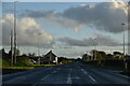
6
Cloyfin Road approaching Junction with B62
Image: © David Dixon
Taken: 28 Sep 2017
0.19 miles