1
The Castlereagh Road, Belfast
The Castleragh Road (A23), a wide arterial route in and out of Belfast from the east.
Image: © Rossographer
Taken: 15 Nov 2021
0.12 miles
2
Needham "Grip-Fix" manhole cover, Belfast (2)
See
Image (Sandy Row). This one is in the footpath on the Castlereagh Road close to Houston Park. This part of the Castlereagh Road is lightly-trodden. The cover is only slightly worn. Note the guide marks (top left) to ensure that the cover is correctly aligned. The design and inscription are emphasised by the side lighting.
Image shows another “Grip-Fix” of older design.
Image: © Albert Bridge
Taken: 17 Nov 2012
0.14 miles
3
Pillar box, Castlereagh, Belfast
GVIR pillar box (BT5 439), beside a litter bin, on the Castlereagh Road, close to Orby Street (Orby Drive) on the Google map.
Image: © Albert Bridge
Taken: 17 Nov 2012
0.16 miles
4
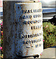
Boundary post, Castlereagh Road, Belfast (1)
Former Belfast Corporation boundary post, at Orangefield Presbyterian church
Image, on the Castlereagh Road.
Image shows the inscription.
Image: © Albert Bridge
Taken: 17 Nov 2012
0.17 miles
5
Boundary post, Castlereagh Road, Belfast (2)
See
Image The inscription “PARLIAMENTARY AND MUNICIPAL BOUNDARY BELFAST POTTINGER DIVISION POTTINGER WARD 1918”.
Image: © Albert Bridge
Taken: 17 Nov 2012
0.17 miles
6
The Robinson Centre, Belfast - January 2017(3)
A sign, on the perimeter fence, announcing the new aquatics centre.
Image: © Albert Bridge
Taken: 15 Jan 2017
0.17 miles
7
E-car charging point, Montgomery Road, Belfast (January 2017)
An e-car charging point, close to the Robinson Centre
Image, on the Montgomery Road.
Image: © Albert Bridge
Taken: 15 Jan 2017
0.17 miles
8
Pillar box, Belfast
GR pillar box, on the Castlereagh Road, opposite Orangefield Crescent.
Image: © Albert Bridge
Taken: 24 May 2011
0.17 miles
9
Boundary Post, Belfast
Old boundary post on the Castlereagh Road, Belfast. The inscription reads:
“PARLIAMENTARY AND MUNICIPAL BOUNDARY OF BELFAST
POTTINGER DIVISION
POTTINGER WARD 1918”.
Previously seen in
Image
Image: © Rossographer
Taken: 15 Nov 2021
0.18 miles
10
The Robinson Centre, Belfast - January 2017(4)
The Montgomery Road side of the building seen from the north west.
Image: © Albert Bridge
Taken: 15 Jan 2017
0.19 miles


