IMAGES TAKEN NEAR TO
Marshalls Road, BELFAST, BT5 6SR
Introduction
This page details the photographs taken nearby to Marshalls Road, BT5 6SR by members of the Geograph project.
The Geograph project started in 2005 with the aim of publishing, organising and preserving representative images for every square kilometre of Great Britain, Ireland and the Isle of Man.

There are currently over 7.5m images from over14,400 individuals and you can help contribute to the project by visiting https://www.geograph.org.uk
Image Map
Images are licensed for reuse under creativecommons.org/licenses/by-sa/2.0
Notes
- Clicking on the map will re-center to the selected point.
- The higher the marker number, the further away the image location is from the centre of the postcode.
Image Listing (17 Images Found)
Images are licensed for reuse under creativecommons.org/licenses/by-sa/2.0
Image
Details
Distance
1
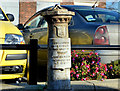
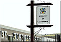
Boundary post, Castlereagh Road, Belfast (1)
Former Belfast Corporation boundary post, at Orangefield Presbyterian church Image, on the Castlereagh Road. Image shows the inscription.
Image: © Albert Bridge
Taken: 17 Nov 2012
0.08 miles
2
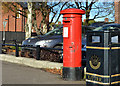
Pillar box, Castlereagh, Belfast
GVIR pillar box (BT5 439), beside a litter bin, on the Castlereagh Road, close to Orby Street (Orby Drive) on the Google map.
Image: © Albert Bridge
Taken: 17 Nov 2012
0.08 miles
3
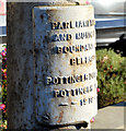
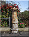
Boundary post, Castlereagh Road, Belfast (2)
See Image The inscription “PARLIAMENTARY AND MUNICIPAL BOUNDARY BELFAST POTTINGER DIVISION POTTINGER WARD 1918”.
Image: © Albert Bridge
Taken: 17 Nov 2012
0.08 miles
4
Boundary Post, Belfast
Old boundary post on the Castlereagh Road, Belfast. The inscription reads:
“PARLIAMENTARY AND MUNICIPAL BOUNDARY OF BELFAST
POTTINGER DIVISION
POTTINGER WARD 1918”.
Previously seen in Image
Image: © Rossographer
Taken: 15 Nov 2021
0.08 miles
5
Castlereagh boundary sign, Belfast (March 2015)
A Castlereagh District boundary sign, on the Castlereagh Road, close to Orangefield Presbyterian church Image Under the new arrangements, for local government, due to take effect on 1 April 2015 Castlereagh and Lisburn districts will merge but part of the former, in this general area, will transfer to Belfast.
Image: © Albert Bridge
Taken: 1 Mar 2015
0.09 miles
6
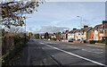
The Castlereagh Road, Belfast
The Castleragh Road (A23), a wide arterial route in and out of Belfast from the east.
Image: © Rossographer
Taken: 15 Nov 2021
0.12 miles
7

"Spend Local" sign, Belfast
Advert on Montgomery Road for the "Spend Local" scheme in which everyone aged 18 and over in Northern Ireland can apply for a £100 card to use in shops before the end of November 2021 (later extended to 14th December). There is an application process and the cards cannot be used for online purchases. The scheme, which has cost the Northern Ireland Executive around £145m, is designed to boost local businesses hit hard by the Covid pandemic. See https://www.bbc.co.uk/news/uk-northern-ireland-58682692 for further details.
Image: © Rossographer
Taken: 15 Nov 2021
0.13 miles
8
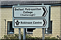
The Robinson Centre, Belfast - January 2017(5)
A direction sign (white) on the Castlereagh Road. I’d expect the replacement, for the new aquatics centre, to be brown.
Image: © Albert Bridge
Taken: 15 Jan 2017
0.15 miles
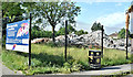
9
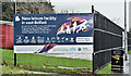
The Robinson Centre, Belfast - January 2017(3)
A sign, on the perimeter fence, announcing the new aquatics centre.
Image: © Albert Bridge
Taken: 15 Jan 2017
0.15 miles
10
The Robinson Centre (demolition), Belfast (June 2017)
Now demolished.
Image: © Albert Bridge
Taken: 18 Jun 2017
0.17 miles