
IMAGES TAKEN NEAR TO
Richhill Crescent, BELFAST, BT5 6HF
Introduction
This page details the photographs taken nearby to Richhill Crescent, BT5 6HF by members of the Geograph project.
The Geograph project started in 2005 with the aim of publishing, organising and preserving representative images for every square kilometre of Great Britain, Ireland and the Isle of Man.

There are currently over 7.5m images from over14,400 individuals and you can help contribute to the project by visiting https://www.geograph.org.uk
Image Map
Images are licensed for reuse under creativecommons.org/licenses/by-sa/2.0
Notes
- Clicking on the map will re-center to the selected point.
- The higher the marker number, the further away the image location is from the centre of the postcode.
Image Listing (52 Images Found)
Images are licensed for reuse under creativecommons.org/licenses/by-sa/2.0
Image
Details
Distance
1
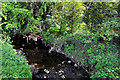
The Knock River, Belfast (6)
See Image The river, looking upstream, as it flows (almost hidden from public view) past Clara Road. Continue to Image
Image: © Albert Bridge
Taken: 21 Apr 2011
0.11 miles
2
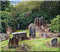
Knock Burial Ground
A selection of the gravestones in Knock Burial Ground. The ground is very uneven and many of the gravestones are in a poor state of repair. Good views over Belfast are possible through gaps in the trees.
Image: © Rossographer
Taken: 11 Sep 2011
0.11 miles
3

Gravestone, Knock Burial Ground
Military gravestone for a Private J. Corbett of the 19th Battalion The Queen's (Royal West Surrey Regiment). Private Corbett died on the 9th March 1919; from east Belfast, his father John Corbett lived at 27 Cuba Street, Newtownards Road.
Also mentioned on the stone is Francis William Corbett who died, aged 15 years and 3 months, on the 2nd March 1917. From what I can gather Francis was a civilian, probably a brother to the above; he is buried at nearby Knockbreda Image
Image: © Rossographer
Taken: 11 Sep 2011
0.11 miles
4

Gravestone, Knock Burial Ground
Gravestone for 5 member of the Best family. Parents George (died 6th May 1948) and Eliza (died 23rd January 1951) tragically outlived their 3 sons.
David Best died on the 23rd October 1918 and James on the 24th February 1921.
A third son, Henry, was killed at the evacuation of Dunkirk on the 28th of May 1940. Henry, aged 25, was a 'Driver' in the 3 Searchlight Regiment of the Royal Artillery; he is buried in St James Cemetery, Dover, Kent.
Image: © Rossographer
Taken: 11 Sep 2011
0.11 miles
5

Gravestone, Knock Burial Ground
Gravestone for a Rose Ann Campbell who died, aged 1 year, on March 1st 1823. The stone was erected by her father Robert Campbell.
Image: © Rossographer
Taken: 11 Sep 2011
0.11 miles
6

Gravestone, Knock Burial Ground
A small gravestone for a William Malone who died on the 8th (possibly 5th) February 1835 (age obscured).
Image: © Rossographer
Taken: 11 Sep 2011
0.12 miles
7

Gravestone, Knock Burial Ground
Detail of a gravestone erected by one Thomas Devlin in memory of his son William who died, aged 20, on May 23rd 1835. Also buried here are three children of (I think) William Devlin.
Image: © Rossographer
Taken: 11 Sep 2011
0.12 miles
8
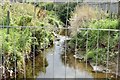
The Knock River, Clara Park, Belfast (September 2015)
The Knock River looking upstream from Clara Park. The flood alleviation works have been completed behind me. More are in progress around the bend in the background. In the meantime this short stretch remains untouched.
Image: © Albert Bridge
Taken: 10 Sep 2015
0.12 miles
9
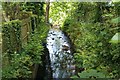
Knock River / Orangefield river
Knock / Orangefield river as it passes under Clara Park
You need to look over the wall
Have always known this as Orangefield river but most other posters call this Knock river
Image: © John Thompson
Taken: 17 May 2014
0.12 miles
10
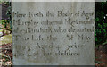
Gravestone, Knock Burial Ground
The grave of one Agnes Murphy along with 4 of her unnamed children. The inscription records that:
"Here lieth the body of Agnes Murphy otherways McClatworthy
of Gillinahirk who departed this life the
17th May 1798 aged 41 years
Also 4 of hir children".
Gillinahirk would once have been a townland to the east of Belfast; today it is part of the city and is known as Gilnahirk.
Image: © Rossographer
Taken: 11 Sep 2011
0.12 miles