IMAGES TAKEN NEAR TO
Clarawood Walk, BELFAST, BT5 6GL
Introduction
This page details the photographs taken nearby to Clarawood Walk, BT5 6GL by members of the Geograph project.
The Geograph project started in 2005 with the aim of publishing, organising and preserving representative images for every square kilometre of Great Britain, Ireland and the Isle of Man.

There are currently over 7.5m images from over14,400 individuals and you can help contribute to the project by visiting https://www.geograph.org.uk
Image Map
Images are licensed for reuse under creativecommons.org/licenses/by-sa/2.0
Notes
- Clicking on the map will re-center to the selected point.
- The higher the marker number, the further away the image location is from the centre of the postcode.
Image Listing (51 Images Found)
Images are licensed for reuse under creativecommons.org/licenses/by-sa/2.0
Image
Details
Distance
1
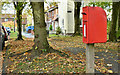
Postbox BT5 791D, Belfast (October 2018)
Post-mounted EIIR postbox (BT5 791D) at Clarawood Park/Clarawood Crescent.
Image: © Albert Bridge
Taken: 31 Oct 2018
0.03 miles
2
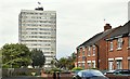
Clarawood House, Belfast (September 2015)
See Image The eastern side of Clarawood House seen from Sandhill Parade.
Image: © Albert Bridge
Taken: 10 Sep 2015
0.04 miles
3
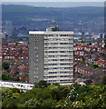
Clarawood House, Belfast
15-storey tower block located at the end of Clara Way in Belfast. The tower, completed in 1967 by local firm F.B. McKee, is 44 metres tall and contains 57 flats. It is part of the Clarawood estate, built in the late 1940s by the Belfast Corporation, although this is the only tower block in the development. The view is from Knock Burial Ground (Knockmount Park).
Image: © Rossographer
Taken: 11 Sep 2011
0.05 miles
4
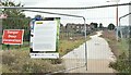
New path, Clarawood, Belfast (September 2015)
A new paved path (not yet open), created as part of the Connswater Greenway scheme, running south, close to the back of Clarawood House Image
Image: © Albert Bridge
Taken: 10 Sep 2015
0.07 miles
5
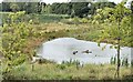
Pond, Orangefield Park, Belfast (September 2015)
A new pond, created as part of the Connswater Greenway scheme, close to the back of Clarawood House Image
Image: © Albert Bridge
Taken: 10 Sep 2015
0.08 miles
6
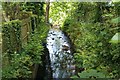
Knock River / Orangefield river
Knock / Orangefield river as it passes under Clara Park
You need to look over the wall
Have always known this as Orangefield river but most other posters call this Knock river
Image: © John Thompson
Taken: 17 May 2014
0.10 miles
7
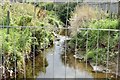
The Knock River, Clara Park, Belfast (September 2015)
The Knock River looking upstream from Clara Park. The flood alleviation works have been completed behind me. More are in progress around the bend in the background. In the meantime this short stretch remains untouched.
Image: © Albert Bridge
Taken: 10 Sep 2015
0.11 miles
8
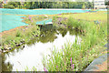
The Knock River, Orangefield Park, Belfast - July 2014(2)
The improved channel of the Knock River and the new flood embankment (left), looking upstream towards Clarawood.
Image: © Albert Bridge
Taken: 12 Jul 2014
0.12 miles
9
Old railway, Belfast (2)
See Image The old line further east.
Image: © Albert Bridge
Taken: 11 Feb 2008
0.15 miles
10
Former Neill's Hill station, Belfast (1)
Neill’s Hill was the next station after Bloomfield Image on the County Down line to Comber, Donaghadee and Newcastle. 58 years after closure the up platform survives (though mostly hidden by the bushes at middle left). The down platform has gone. The track is a path Image now renamed the “Comber Greenway”. Continue to Image
Image: © Albert Bridge
Taken: 11 Feb 2008
0.16 miles