1
Boundary Post, Belfast
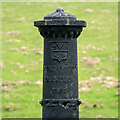
Old boundary post in the grounds of Grosvenor Grammar School in Belfast. Interestingly, the normal faceplate has been removed to reveal the words and date:
“MUNICIPAL BOUNDARY
1853"
This dates the post to much earlier than I had thought and I have not found any others with this inscription.
Image: © Rossographer
Taken: 10 Aug 2023
0.13 miles
2
Postbox BT5 791D, Belfast (October 2018)
Post-mounted EIIR postbox (BT5 791D) at Clarawood Park/Clarawood Crescent.
Image: © Albert Bridge
Taken: 31 Oct 2018
0.13 miles
3
Boundary Post, Belfast
Old boundary post in the grounds of Grosvenor Grammar School in Belfast. Interestingly, the normal faceplate has been removed to reveal the words and date:
“MUNICIPAL BOUNDARY
1853"
This dates the post to much earlier than I had thought and I have not found any others with this inscription.
Image: © Rossographer
Taken: 10 Aug 2023
0.13 miles
4
Clarawood House, Belfast (September 2015)
See
Image The eastern side of Clarawood House seen from Sandhill Parade.
Image: © Albert Bridge
Taken: 10 Sep 2015
0.15 miles
5
New path, Clarawood, Belfast (September 2015)
A new paved path (not yet open), created as part of the Connswater Greenway scheme, running south, close to the back of Clarawood House
Image
Image: © Albert Bridge
Taken: 10 Sep 2015
0.17 miles
6
Clarawood House, Belfast
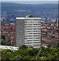
15-storey tower block located at the end of Clara Way in Belfast. The tower, completed in 1967 by local firm F.B. McKee, is 44 metres tall and contains 57 flats. It is part of the Clarawood estate, built in the late 1940s by the Belfast Corporation, although this is the only tower block in the development. The view is from Knock Burial Ground (Knockmount Park).
Image: © Rossographer
Taken: 11 Sep 2011
0.17 miles
7
Pond, Orangefield Park, Belfast (September 2015)
A new pond, created as part of the Connswater Greenway scheme, close to the back of Clarawood House
Image
Image: © Albert Bridge
Taken: 10 Sep 2015
0.17 miles
8
Knock River / Orangefield river
Knock / Orangefield river as it passes under Clara Park
You need to look over the wall
Have always known this as Orangefield river but most other posters call this Knock river
Image: © John Thompson
Taken: 17 May 2014
0.18 miles
9
The Knock River, Clara Park, Belfast (September 2015)
The Knock River looking upstream from Clara Park. The flood alleviation works have been completed behind me. More are in progress around the bend in the background. In the meantime this short stretch remains untouched.
Image: © Albert Bridge
Taken: 10 Sep 2015
0.19 miles
10
The Knock River, Orangefield Park, Belfast - July 2014(2)
The improved channel of the Knock River and the new flood embankment (left), looking upstream towards Clarawood.
Image: © Albert Bridge
Taken: 12 Jul 2014
0.20 miles


