IMAGES TAKEN NEAR TO
Holland Drive, BELFAST, BT5 6EJ
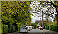
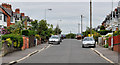
Introduction
This page details the photographs taken nearby to Holland Drive, BT5 6EJ by members of the Geograph project.
The Geograph project started in 2005 with the aim of publishing, organising and preserving representative images for every square kilometre of Great Britain, Ireland and the Isle of Man.

There are currently over 7.5m images from over14,400 individuals and you can help contribute to the project by visiting https://www.geograph.org.uk
Image Map
Images are licensed for reuse under creativecommons.org/licenses/by-sa/2.0
Notes
- Clicking on the map will re-center to the selected point.
- The higher the marker number, the further away the image location is from the centre of the postcode.
Image Listing (329 Images Found)
Images are licensed for reuse under creativecommons.org/licenses/by-sa/2.0
Image
Details
Distance
1
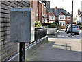
Drop box, Belfast
A drop box at Holland Drive, close to Holland Gardens (middle background).
Image: © Albert Bridge
Taken: 5 Mar 2012
0.02 miles
2
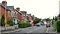
Holland Crescent, Belfast
A street, mainly of semis, built after WW1, off Holland Drive.
Image: © Albert Bridge
Taken: 15 Jul 2011
0.04 miles
3
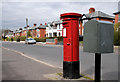
Pillar box, Belfast
GVIR pillar box in Kirkliston Park Image near Holland Drive.
Image: © Albert Bridge
Taken: 28 Mar 2011
0.07 miles
4
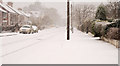
Kirkliston Park, Belfast (2)
See Image The view, towards the North Road, during the worst of today’s snow.
Image: © Albert Bridge
Taken: 6 Jan 2010
0.07 miles
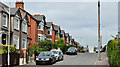
5
Cyprus Park, Belfast
See Image (December 2009). A late 19th century street on the eastern side of the North Road. At the turn of the last century its residents included two members of the clergy and the company secretary of the Musgrave Foundry Image
Image: © Albert Bridge
Taken: 28 Apr 2012
0.09 miles
6
Holland Gardens, Belfast
Holland Gardens runs from Holland Drive to Kirkliston Gardens (behind me). This end, which is quite close to the Comber Greenway Image, lies in a dip. The street seems to have been built after WW1.
Image: © Albert Bridge
Taken: 2 Jun 2011
0.09 miles
7
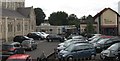
St Joseph's Primary School, Ballyhackamore
This is a primary school of the Roman Catholic Parish of Colmcilles. The two other buildings in the image are the Parish Church of Colmcilles and the Parochial Hall.
Image: © Eric Jones
Taken: 26 Jun 2017
0.10 miles
8
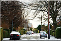
December snow, Belfast 2009-9
See Image By 11.05 Cyprus Park had only a light coating of snow. Continue to Image Image shows the street in April 2012 – without snow.
Image: © Albert Bridge
Taken: 20 Dec 2009
0.10 miles
9
Kirkliston Park, Belfast (3)
The south eastern end of Kirkliston Park Image which, like its neighbour Holland Gardens Image, sits in a dip.
Image: © Albert Bridge
Taken: 2 Jun 2011
0.10 miles
10
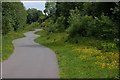
Old railway, Belfast
See Image This is a view of the old line/footpath looking towards Comber. It was managed by the Conservation Volunteers as a semi-wild area but was substantially altered, a few years ago, when a new water main was laid under this section. Many would like to see it re-opened as a tramway but official thinking is directed towards a guided busway Image
Image: © Albert Bridge
Taken: 30 May 2007
0.10 miles