IMAGES TAKEN NEAR TO
Holland Gardens, BELFAST, BT5 6EG
Introduction
This page details the photographs taken nearby to Holland Gardens, BT5 6EG by members of the Geograph project.
The Geograph project started in 2005 with the aim of publishing, organising and preserving representative images for every square kilometre of Great Britain, Ireland and the Isle of Man.

There are currently over 7.5m images from over14,400 individuals and you can help contribute to the project by visiting https://www.geograph.org.uk
Image Map
Images are licensed for reuse under creativecommons.org/licenses/by-sa/2.0
Notes
- Clicking on the map will re-center to the selected point.
- The higher the marker number, the further away the image location is from the centre of the postcode.
Image Listing (281 Images Found)
Images are licensed for reuse under creativecommons.org/licenses/by-sa/2.0
Image
Details
Distance
1
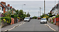
Kirkliston Park, Belfast (3)
The south eastern end of Kirkliston Park Image which, like its neighbour Holland Gardens Image, sits in a dip.
Image: © Albert Bridge
Taken: 2 Jun 2011
0.04 miles
2
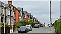
Holland Gardens, Belfast
Holland Gardens runs from Holland Drive to Kirkliston Gardens (behind me). This end, which is quite close to the Comber Greenway Image, lies in a dip. The street seems to have been built after WW1.
Image: © Albert Bridge
Taken: 2 Jun 2011
0.04 miles
3
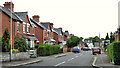
Holland Crescent, Belfast
A street, mainly of semis, built after WW1, off Holland Drive.
Image: © Albert Bridge
Taken: 15 Jul 2011
0.05 miles
4
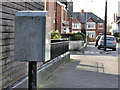
Drop box, Belfast
A drop box at Holland Drive, close to Holland Gardens (middle background).
Image: © Albert Bridge
Taken: 5 Mar 2012
0.05 miles
5
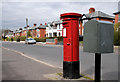
Pillar box, Belfast
GVIR pillar box in Kirkliston Park Image near Holland Drive.
Image: © Albert Bridge
Taken: 28 Mar 2011
0.07 miles
6
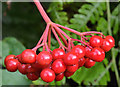
Cotoneaster berries, Belfast (3)
Cotoneaster berries growing along the Comber Greenway, between the Sandown and North Roads.
Image: © Albert Bridge
Taken: 9 Sep 2013
0.08 miles
7
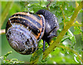
Snail, Belfast (3)
A snail, feeding on leaves, along the Comber Greenway, between the Sandown and North Roads.
Image: © Albert Bridge
Taken: 9 Sep 2013
0.08 miles
8
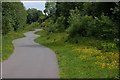
Old railway, Belfast
See Image This is a view of the old line/footpath looking towards Comber. It was managed by the Conservation Volunteers as a semi-wild area but was substantially altered, a few years ago, when a new water main was laid under this section. Many would like to see it re-opened as a tramway but official thinking is directed towards a guided busway Image
Image: © Albert Bridge
Taken: 30 May 2007
0.08 miles
9
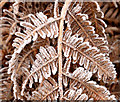
Frosty bracken, Belfast
There was quite a heavy frost overnight. This bracken is beside the Comber Greenway.
Image: © Albert Bridge
Taken: 14 Jan 2014
0.08 miles
10
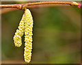
Catkins, Belfast
Some of the many hazel catkins, now in flower, along the Comber Greenway.
Image: © Albert Bridge
Taken: 14 Jan 2014
0.08 miles