IMAGES TAKEN NEAR TO
North Gardens, BELFAST, BT5 6BZ
Introduction
This page details the photographs taken nearby to North Gardens, BT5 6BZ by members of the Geograph project.
The Geograph project started in 2005 with the aim of publishing, organising and preserving representative images for every square kilometre of Great Britain, Ireland and the Isle of Man.

There are currently over 7.5m images from over14,400 individuals and you can help contribute to the project by visiting https://www.geograph.org.uk
Image Map
Images are licensed for reuse under creativecommons.org/licenses/by-sa/2.0
Notes
- Clicking on the map will re-center to the selected point.
- The higher the marker number, the further away the image location is from the centre of the postcode.
Image Listing (129 Images Found)
Images are licensed for reuse under creativecommons.org/licenses/by-sa/2.0
Image
Details
Distance
1
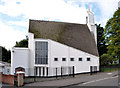
Orangefield Baptist church, Belfast (3)
The church seen from the Orangefield Road.
Image: © Albert Bridge
Taken: 9 Sep 2013
0.07 miles
2
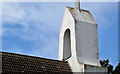
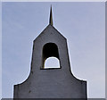
Orangefield Baptist church, Belfast (4)
The false belfry seen from the Orangefield Road.
Image: © Albert Bridge
Taken: 9 Sep 2013
0.07 miles
3
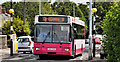
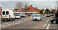
Bus, Bloomfield, Belfast
A Metro Alexander (Belfast) – bodied Volvo pausing at the Bloomfield roundabout Image with service no 18 - Gilnahirk to Donegall Square West via the Bloomfield and Beersbridge Roads (every 30 minutes). Before the introduction of the Metro branding the North Road – Donegall Square West route was Citybus service no 17. The buses show “Gilnahirk” on the outward journeys although the service terminates, past the Gilnahirk Road, at The Braniel.
The route is also served by the half-hourly no 19 to the Ulster Hospital, Dundonald.
Image: © Albert Bridge
Taken: 2 Jun 2011
0.07 miles
4
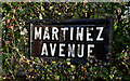
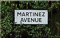
Martinez Avenue sign, Belfast (1)
Traditional tiled sign, at the North Road end of Martinez Avenue Image (north eastern side). Continue to Image
Image: © Albert Bridge
Taken: 25 Jan 2010
0.08 miles
5
Martinez Avenue sign, Belfast (2)
See Image The modern equivalent - at the North Road end of Martinez Avenue Image (south western side).
Image: © Albert Bridge
Taken: 25 Jan 2010
0.08 miles
6
Orangefield Baptist church, Belfast (2)
The church also includes this sham belfry, surmounted by a small spire.
Image: © Albert Bridge
Taken: 19 Dec 2011
0.08 miles
7
The Bloomfield roundabout, Belfast
A busy suburban roundabout where Grand Parade (foreground) meets the Bloomfield Road (left), the North Road (middle right) and Orangefield Lane (right).
Originally the site of “Ivy Cottage” a gate lodge at the entrance to the former Orangefield Demesne.
Image: © Albert Bridge
Taken: 28 Mar 2011
0.08 miles
8
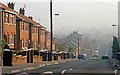
The Orangefield Road, Belfast
The long period of post-WW1 depression finally ended in the 50’s. In Belfast it was particularly noticeable in the east as new factories opened and new houses were built on previously undeveloped land. The Orangefield Road is typical of the architecture of the area and the period. The view is from the North Road Image towards the Sandown Road. The traffic calming humps are a much later addition. Continue to Image
Image: © Albert Bridge
Taken: 11 Feb 2008
0.08 miles
9
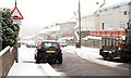
Orangefield Lane, Belfast
The view along Orangefield Lane, from the Grand Parade end, during the worst of today’s snow.
Image: © Albert Bridge
Taken: 6 Jan 2010
0.09 miles
10
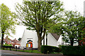
Orangefield Baptist Church, Belfast
The view from the North Road.
Image: © Albert Bridge
Taken: 4 May 2010
0.09 miles