IMAGES TAKEN NEAR TO
Houston Drive, BELFAST, BT5 6AZ
Introduction
This page details the photographs taken nearby to Houston Drive, BT5 6AZ by members of the Geograph project.
The Geograph project started in 2005 with the aim of publishing, organising and preserving representative images for every square kilometre of Great Britain, Ireland and the Isle of Man.

There are currently over 7.5m images from over14,400 individuals and you can help contribute to the project by visiting https://www.geograph.org.uk
Image Map
Images are licensed for reuse under creativecommons.org/licenses/by-sa/2.0
Notes
- Clicking on the map will re-center to the selected point.
- The higher the marker number, the further away the image location is from the centre of the postcode.
Image Listing (28 Images Found)
Images are licensed for reuse under creativecommons.org/licenses/by-sa/2.0
Image
Details
Distance
1
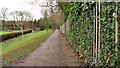
Houston Park, Belfast
A long street, built in the “inter-war” period, running north east off the Castlereagh Road. Orangefield Park http://www.geograph.org.uk/snippet/6092 is on the left and straight ahead.
Image: © Albert Bridge
Taken: 1 Feb 2014
0.04 miles
2
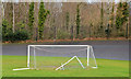
Goalposts and cycle track, Orangefield Park, Belfast
The eastern side of Orangefield Park seen from close to Houston Park. The hockey goalposts seem to be disused. The cycle track/velodrome (background) opened in 1957 and is still in use.
Image: © Albert Bridge
Taken: 1 Feb 2014
0.18 miles
3
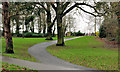
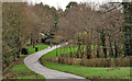
Park path, Belfast (2)
A path in Orangefield Park.
Image: © Albert Bridge
Taken: 31 Dec 2011
0.19 miles
4
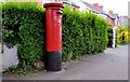
Pillar box, Belfast
GR pillar box, on the Castlereagh Road, opposite Orangefield Crescent.
Image: © Albert Bridge
Taken: 24 May 2011
0.20 miles
5
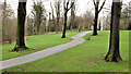
Park path, Belfast (1)
This path (to the best of my knowledge) marks the “boundary” between Greenville Park (left) and Orangefield Park and playing fields. The Knock River Image is out of picture to the left. The view is towards Orangefield Lane Image
Image: © Albert Bridge
Taken: 31 Dec 2011
0.20 miles
6
Park seat and path, Belfast (2)
This path (to the best of my knowledge) marks the “boundary” between Greenville Park (left) and Orangefield Park and playing fields. The Knock River Image is below the trees at middle/left.
Image: © Albert Bridge
Taken: 31 Dec 2011
0.20 miles
7
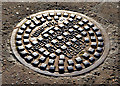
Needham "Grip-Fix" manhole cover, Belfast (2)
See Image (Sandy Row). This one is in the footpath on the Castlereagh Road close to Houston Park. This part of the Castlereagh Road is lightly-trodden. The cover is only slightly worn. Note the guide marks (top left) to ensure that the cover is correctly aligned. The design and inscription are emphasised by the side lighting. Image shows another “Grip-Fix” of older design.
Image: © Albert Bridge
Taken: 17 Nov 2012
0.21 miles
8
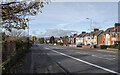
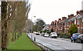
The Castlereagh Road, Belfast
The Castleragh Road (A23), a wide arterial route in and out of Belfast from the east.
Image: © Rossographer
Taken: 15 Nov 2021
0.21 miles
9
Park path, Belfast (4)
A path, in Orangefield Park, beside the bowling green Image (left).
Image: © Albert Bridge
Taken: 31 Dec 2011
0.22 miles
10
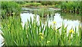
Flag iris, Orangefield Park, Belfast (May 2015)
See Image Just over a year later as the new flag iris plants are coming into flower.
Image: © Albert Bridge
Taken: 30 May 2015
0.23 miles