IMAGES TAKEN NEAR TO
Dunluce Road, PORTRUSH, BT56 8NA
Introduction
This page details the photographs taken nearby to Dunluce Road, BT56 8NA by members of the Geograph project.
The Geograph project started in 2005 with the aim of publishing, organising and preserving representative images for every square kilometre of Great Britain, Ireland and the Isle of Man.

There are currently over 7.5m images from over14,400 individuals and you can help contribute to the project by visiting https://www.geograph.org.uk
Image Map
Images are licensed for reuse under creativecommons.org/licenses/by-sa/2.0
Notes
- Clicking on the map will re-center to the selected point.
- The higher the marker number, the further away the image location is from the centre of the postcode.
Image Listing (46 Images Found)
Images are licensed for reuse under creativecommons.org/licenses/by-sa/2.0
Image
Details
Distance
1
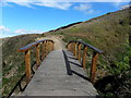
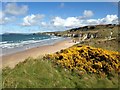
Footbridge, Portrush
Pictured along the coastal path near the Whiterocks
Image: © Kenneth Allen
Taken: 27 Apr 2016
0.03 miles
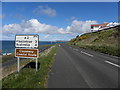
3
Road sign near Portrush
There are many roads in NI suitable for only one vehicle at a time. Signposted passing places such as this one, on the road to the Whiterocks near Portrush, are unusual.
Image: © Albert Bridge
Taken: 28 Sep 2007
0.05 miles
4
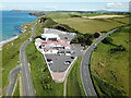
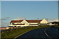
Royal Court Hotel
Royal Court Hotel on the North Antrim coast N. Ireland, with the Giant's Causeway and Knocklayde mountain in the distance.
Image: © KS
Taken: 1 Jun 2022
0.06 miles
5
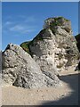
Chalk stacks
Chalk stacks at the top of the shore are standing proud of the degraded cliff line. Their isolation and curious, rubbly texture which differs from much of the Ulster White Limestone Formation in the area is indicative of an unusual geological context. Careful examination shows the presence of large, rounded boulders of basalt within the chalk. The inclusion of younger rock is indicative of eruption processes associated with basalt volcanism, and probably the result of phreatic eruptions which co-mingled pre-existing chalk and basalt while creating a pipe-like void. The debris which settled into the pipes has been re-cemented by continuing steam and fluid flow.
Image: © Jonathan Wilkins
Taken: 6 Sep 2024
0.06 miles
6
Stradly Rock, Curran Strand, E of Portrush
Image: © Colin Park
Taken: 13 Jun 2019
0.06 miles
8
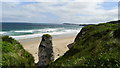
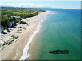
White Rocks Bay, Portrush
Looking east from the end of the golf course
Image: © Kenneth Allen
Taken: 27 Apr 2016
0.07 miles
9
Devereux Ship
At very low tides the remains of the wreck of the Devereux can sometimes be seen protruding from the sands at Portrush's White Rocks Beach
Image: © KS
Taken: 1 Jun 2022
0.07 miles
10
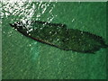
Devereux ship
At very low tides the remains of the wreck of the Devereux can sometimes be seen protruding from the sands at Portrush's White Rocks Beach
Image: © KS
Taken: 1 Jun 2022
0.07 miles