IMAGES TAKEN NEAR TO
Castlereagh Road, BELFAST, BT5 5FP
Introduction
This page details the photographs taken nearby to Castlereagh Road, BT5 5FP by members of the Geograph project.
The Geograph project started in 2005 with the aim of publishing, organising and preserving representative images for every square kilometre of Great Britain, Ireland and the Isle of Man.

There are currently over 7.5m images from over14,400 individuals and you can help contribute to the project by visiting https://www.geograph.org.uk
Image Map
Images are licensed for reuse under creativecommons.org/licenses/by-sa/2.0
Notes
- Clicking on the map will re-center to the selected point.
- The higher the marker number, the further away the image location is from the centre of the postcode.
Image Listing (136 Images Found)
Images are licensed for reuse under creativecommons.org/licenses/by-sa/2.0
Image
Details
Distance
1
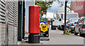
Pillar box, Belfast
EIIR pillar box, outside the Castlereagh Road post office, near Ravensdale Street.
Image: © Albert Bridge
Taken: 15 Jul 2011
0.01 miles
2
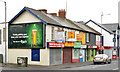
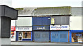
Shops, Castlereagh Road, Belfast
A block of shops, some occupied and some vacant, at the corner of Willowfield Street (left). The one with the “sold” sign was advertised as no 55.
Image: © Albert Bridge
Taken: 7 Dec 2013
0.03 miles
3
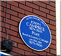
Joseph Campbell plaque, Belfast
A plaque, at Ravensdale Street, on the Castlereagh Road, commemorating the poet Joseph Campbell http://www.ulsterhistory.co.uk/josephcampbell.htm.
Image: © Albert Bridge
Taken: 3 Jan 2010
0.03 miles
4
Nos 136-152 Beersbridge Road, Belfast (2)
See Image The same block of derelict shops, looking in the other direction. The Avoniel Road is second left. Continue to Image (December 2013).
Image: © Albert Bridge
Taken: 19 Dec 2011
0.06 miles
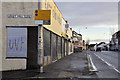
5
Nos 19&21 Castlereagh Road, Belfast (December 2017)
Nos 19 and 21 are currently vacant.
Image: © Albert Bridge
Taken: 7 Dec 2017
0.07 miles
6
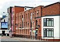
"The Sorting Office", Belfast
Apartments, on the Beersbridge Road, named after the East Belfast Sorting Office which previously occupied the site.
Image: © Albert Bridge
Taken: 15 Jul 2011
0.07 miles
7
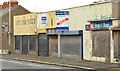
Nos 136-152 Beersbridge Road, Belfast
See Image (December 2011). A long-vacant and semi-derelict block now with a “sold” sign.
Image: © Albert Bridge
Taken: 7 Dec 2013
0.07 miles
8
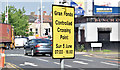
Grand Fondo sign, Belfast (June 2016)
Some roads in east Belfast and parts of Co Down were closed yesterday for the passing of a gran fondo cycle race https://en.wikipedia.org/wiki/Gran_Fondo. Crossing the route was by means of controlled “gateways” at selected places. This sign is at the Castlereagh Road end of the Beersbridge Road. See also http://www.geograph.org.uk/of/Giro+d%27Italia+templepatrick.
Image: © Albert Bridge
Taken: 6 Jun 2016
0.07 miles
9
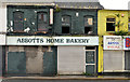
Nos 1-21 Castlereagh Road, Belfast (2)
The former “Abbots” home bakery.
Image: © Albert Bridge
Taken: 17 Oct 2012
0.07 miles
10
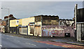
Nos 136-152 Beersbridge Road, Belfast (1)
A row of derelict shops, on the Beersbridge Road, at the corner of the Avoniel Road (right), awaiting redevelopment. Image shows the view in the other direction.
Image: © Albert Bridge
Taken: 19 Dec 2011
0.07 miles