1
Pillar box, Belfast
EIIR pillar box, outside the Castlereagh Road post office, near Ravensdale Street.
Image: © Albert Bridge
Taken: 15 Jul 2011
0.07 miles
2
Shops, Castlereagh Road, Belfast
A block of shops, some occupied and some vacant, at the corner of Willowfield Street (left). The one with the “sold” sign was advertised as no 55.
Image: © Albert Bridge
Taken: 7 Dec 2013
0.07 miles
3
Newry Street, Belfast
A street running from Euston Street to the Castlereagh Road (background). Built in the late 19th century and now rebuilt as shown.
Image: © Albert Bridge
Taken: 16 Nov 2011
0.08 miles
4
Castlereagh Road, Belfast
Looking south-east along the Castlereagh Road, east Belfast
Image: © Patrick Brown
Taken: 27 Aug 2005
0.09 miles
5
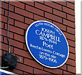
Joseph Campbell plaque, Belfast
A plaque, at Ravensdale Street, on the Castlereagh Road, commemorating the poet Joseph Campbell http://www.ulsterhistory.co.uk/josephcampbell.htm.
Image: © Albert Bridge
Taken: 3 Jan 2010
0.09 miles
6
Glenvarlock Street, Belfast (2)
The white-on-black name sign at the Castlereagh Road end of Glenvarlock Street
Image (southern side).
Image: © Albert Bridge
Taken: 19 Dec 2011
0.10 miles
7
Glenvarlock Street, Belfast (3)
The tiled name sign at the Castlereagh Road end of Glenvarlock Street
Image (northern side).
Image: © Albert Bridge
Taken: 19 Dec 2011
0.10 miles
8
Nos 167 - 177 Beersbridge Road, Belfast (December 2015)
A row of vacant shops which were to have been auctioned, as three lots, on 19 March 2015. The agents’ website refers to the middle one as “Unsold. Please refer to Auctioneer. Prominent mid terrace retail property Comprising a retail unit with office accommodation above Extending to approximately 825 sq ft (76.6 sq m) Ideal owner occupier or investor purchase”. This photograph appears as a matter of record only. I have no connection with any of the parties involved in the sale.
Image: © Albert Bridge
Taken: 14 Dec 2015
0.10 miles
9
Nos 179-181 Beersbridge Road, Belfast (December 2017)
Three vacant properties which had the following planning permission (23 September 2009) “Z/2008/0014/F 18 No. Apartments, car parking, and associated site works. 179/181 Beersbridge Road, Ballymacarret, Belfast, BT05 4RR”. The site of nos 183-191
Image is on the left.
Image: © Albert Bridge
Taken: 7 Dec 2017
0.10 miles
10
Nos 136-152 Beersbridge Road, Belfast (2)
See
Image The same block of derelict shops, looking in the other direction. The Avoniel Road is second left. Continue to
Image (December 2013).
Image: © Albert Bridge
Taken: 19 Dec 2011
0.10 miles


