IMAGES TAKEN NEAR TO
Greenville Road, BELFAST, BT5 5EP
Introduction
This page details the photographs taken nearby to Greenville Road, BT5 5EP by members of the Geograph project.
The Geograph project started in 2005 with the aim of publishing, organising and preserving representative images for every square kilometre of Great Britain, Ireland and the Isle of Man.

There are currently over 7.5m images from over14,400 individuals and you can help contribute to the project by visiting https://www.geograph.org.uk
Image Map
Images are licensed for reuse under creativecommons.org/licenses/by-sa/2.0
Notes
- Clicking on the map will re-center to the selected point.
- The higher the marker number, the further away the image location is from the centre of the postcode.
Image Listing (179 Images Found)
Images are licensed for reuse under creativecommons.org/licenses/by-sa/2.0
Image
Details
Distance
1
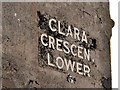
Clara Crescent Lower, Belfast (2)
The name sign at the Greenville Road end of Clara Crescent Lower Image The peeling black background was painted. The letters are raised and seem to have been applied individually – an unusual style of street sign.
Image: © Albert Bridge
Taken: 5 Mar 2012
0.01 miles
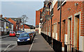
2
Clara Crescent Lower, Belfast (1)
A late 19th century street running from the Greenville Road to Clara Avenue (background). At the time of building it seems to have been known as “Clara Crescent” and appears to have been renamed to avoid confusion with the existing Clara Crescent Upper. Image shows the unusual name sign at the Greenville Road end.
Image: © Albert Bridge
Taken: 5 Mar 2012
0.03 miles
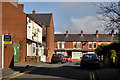
3
Scott's Villas, Belfast
A row of modern terrace/town houses at the Beersbridge Road end of Hyndford Street – also visible (left) in Image
Image: © Albert Bridge
Taken: 16 Nov 2011
0.03 miles
4
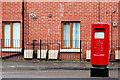
Pillar box, Belfast
EIIR pillar box on the Beersbridge Road. Hyndford Street Image is in the background.
Image: © Albert Bridge
Taken: 18 Feb 2011
0.06 miles
5
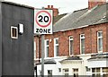
20 mph speed limit sign, Beersbridge Road, Belfast (September 2015)
A 20mph speed limit sign at the Beersbridge Road end of Greenville Road – one of several similarly restricted streets in the general area.
Image: © Albert Bridge
Taken: 12 Sep 2015
0.06 miles
6
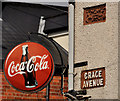
Grace Avenue sign, Belfast
Cast name sign and illuminated Coca-Cola sign, on a corner shop at the Woodcot Avenue end of Grace Avenue Image
Image: © Albert Bridge
Taken: 5 Mar 2012
0.06 miles
7
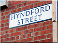
Hyndford Street sign, Belfast
See Image The sign at the Beersbridge Road end. High enough to discourage (but probably not deter) souvenir hunters.
Image: © Albert Bridge
Taken: 25 Jan 2010
0.06 miles
8
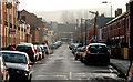
Hyndford Street, Belfast
A street, of terrace houses, off the Beersbridge Road. There has been some redevelopment on the north eastern (left) side. Better known as the childhood home of George Ivan Morrison. Image shows the view in the opposite direction in April 2012.
Image: © Albert Bridge
Taken: 25 Jan 2010
0.06 miles
9
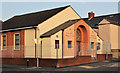
Bloomfield gospel hall, Belfast
Gospel hall at the corner of Hyndford Street Image (left) and Woodcot Avenue.
Image: © Albert Bridge
Taken: 16 Nov 2011
0.06 miles
10
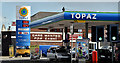
Topaz petrol station, Belfast (April 2016)
Topaz petrol station on the Beersbridge Road.
Image: © Albert Bridge
Taken: 27 Apr 2016
0.06 miles