IMAGES TAKEN NEAR TO
Hyndford Street, BELFAST, BT5 5EN
Introduction
This page details the photographs taken nearby to Hyndford Street, BT5 5EN by members of the Geograph project.
The Geograph project started in 2005 with the aim of publishing, organising and preserving representative images for every square kilometre of Great Britain, Ireland and the Isle of Man.

There are currently over 7.5m images from over14,400 individuals and you can help contribute to the project by visiting https://www.geograph.org.uk
Image Map
Images are licensed for reuse under creativecommons.org/licenses/by-sa/2.0
Notes
- Clicking on the map will re-center to the selected point.
- The higher the marker number, the further away the image location is from the centre of the postcode.
Image Listing (173 Images Found)
Images are licensed for reuse under creativecommons.org/licenses/by-sa/2.0
Image
Details
Distance
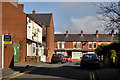
1
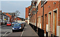
Scott's Villas, Belfast
A row of modern terrace/town houses at the Beersbridge Road end of Hyndford Street – also visible (left) in Image
Image: © Albert Bridge
Taken: 16 Nov 2011
0.02 miles
2
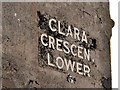
Clara Crescent Lower, Belfast (2)
The name sign at the Greenville Road end of Clara Crescent Lower Image The peeling black background was painted. The letters are raised and seem to have been applied individually – an unusual style of street sign.
Image: © Albert Bridge
Taken: 5 Mar 2012
0.03 miles
3
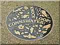
Connswater ground plaque, The Hollow, Belfast (October 2017)
Excellent ground plaque, behind Abetta Parade, commemorating the completion of the Connswater Greenway scheme.
Image: © Albert Bridge
Taken: 23 Oct 2017
0.04 miles
4
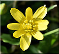
Celandine, Connswater, Belfast (March 2018)
Celandine, a sign of Spring, growing at The Hollow.
Image: © Albert Bridge
Taken: 12 Mar 2018
0.04 miles
5
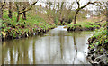
The Knock and Loop Rivers, Belfast
The confluence of the Knock River Image (left) and the Loop River Image, immediately upstream of Con O’Neill’s bridge Image, to form the Connswater Image foreground. The wide-angle lens makes them look much broader than reality. To see both of these majestic watercourses look at the satellite photograph – at maximum zoom.
Image: © Albert Bridge
Taken: 31 Dec 2011
0.05 miles
6
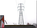
Pylon and power lines, east Belfast (10)
Pylon and power lines close to the Beersbridge Road – the southward continuation of Image Continue to Image
Image: © Albert Bridge
Taken: 18 Feb 2011
0.05 miles
7
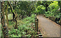
Connswater path, Belfast
A path, beside the Connswater (hidden – left) between Abetta Parade and the Beersbridge Road. Image shows the path after Connswater Greenway improvements.
Image: © Albert Bridge
Taken: 22 Aug 2011
0.05 miles
8
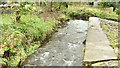
The Connswater at The Hollow, Belfast (October 2017)
The Connswater, immediately downstream from the Knock River/Loop River confluence, looking much better than it did six years ago Image (August 2011).
Image: © Albert Bridge
Taken: 23 Oct 2017
0.05 miles
9
Clara Crescent Lower, Belfast (1)
A late 19th century street running from the Greenville Road to Clara Avenue (background). At the time of building it seems to have been known as “Clara Crescent” and appears to have been renamed to avoid confusion with the existing Clara Crescent Upper. Image shows the unusual name sign at the Greenville Road end.
Image: © Albert Bridge
Taken: 5 Mar 2012
0.05 miles
10
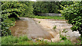
The Connswater in flood, Belfast
The Connswater, in flood, immediately downstream from here Image at the back of Abetta Parade. The confluence of the Knock and Loop Rivers was out of reach due to the amount and level of the water. Media reports suggest that 70% of June’s rain had fallen in one day.
Image: © Albert Bridge
Taken: 22 Jun 2012
0.05 miles