IMAGES TAKEN NEAR TO
Beersbridge Road, BELFAST, BT5 5DU
Introduction
This page details the photographs taken nearby to Beersbridge Road, BT5 5DU by members of the Geograph project.
The Geograph project started in 2005 with the aim of publishing, organising and preserving representative images for every square kilometre of Great Britain, Ireland and the Isle of Man.

There are currently over 7.5m images from over14,400 individuals and you can help contribute to the project by visiting https://www.geograph.org.uk
Image Map
Images are licensed for reuse under creativecommons.org/licenses/by-sa/2.0
Notes
- Clicking on the map will re-center to the selected point.
- The higher the marker number, the further away the image location is from the centre of the postcode.
Image Listing (227 Images Found)
Images are licensed for reuse under creativecommons.org/licenses/by-sa/2.0
Image
Details
Distance
2
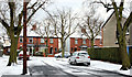
December snow, Belfast 2009-7
See Image By 10.40, Sagimor Gardens, off the Beersbridge Road, had slightly more than a light dusting of snow. Continue to Image
Image: © Albert Bridge
Taken: 20 Dec 2009
0.03 miles
3
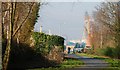
Old railway, Belfast (4)
See Image This is the line as it approaches the site of Bloomfield station Image on the Beersbridge Road. The slight elevation here gives a good view, even on a misty day, of the Stena ferry berth and the Harland & Wolff cranes (middle right).
Image: © Albert Bridge
Taken: 11 Feb 2008
0.04 miles
4
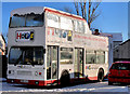
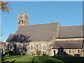
"Hope" bus, Belfast
A partly open-top double decker in the livery of “Hope” (“Churches Together”) parked in the car park behind St Donard’s CoI church Image
Image: © Albert Bridge
Taken: 19 Dec 2010
0.05 miles
5
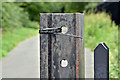
Old rail (?), Comber Greenway, Belfast (August 2017)
At first glance this looks like a piece of old bullhead rail at the Beersbridge Road entrance to the Comber Greenway. A second glance shows the inscription “STEEL 95” near ground level.
Image: © Albert Bridge
Taken: 28 Aug 2017
0.05 miles
6
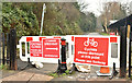
The Comber Greenway, Beersbridge Road, Belfast (February 2018)
See Image The closed entrance on the Beersbridge Road.
Image: © Albert Bridge
Taken: 5 Feb 2018
0.05 miles
7
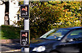
"PUFFIN" crossing, Belfast
Puffin crossings (explained in Image) are becoming more common. This one, which incorporates a cycle aspect, is where the Comber Greenway Image (part of national Cycle Route no 99 Image) crosses the Beersbridge Road.
Image: © Albert Bridge
Taken: 15 Oct 2012
0.06 miles
9
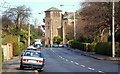
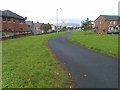
The Beersbridge Road, Belfast
The Beersbridge Road runs from the Woodstock Road to the Upper Newtownards Road. This is the view towards the latter from past the Bloomfield Road Image The old County Down railway crossed the road by a level crossing Image
Image: © Albert Bridge
Taken: 11 Mar 2008
0.06 miles
10
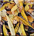
Autumn leaves, Comber Greenway, Belfast - November 2015(3)
Fallen autumn leaves at the Beersbridge Road end of the Comber Greenway.
Image: © Albert Bridge
Taken: 6 Nov 2015
0.06 miles