IMAGES TAKEN NEAR TO
Templemore Place, BELFAST, BT5 4SZ
Introduction
This page details the photographs taken nearby to Templemore Place, BT5 4SZ by members of the Geograph project.
The Geograph project started in 2005 with the aim of publishing, organising and preserving representative images for every square kilometre of Great Britain, Ireland and the Isle of Man.

There are currently over 7.5m images from over14,400 individuals and you can help contribute to the project by visiting https://www.geograph.org.uk
Image Map
Images are licensed for reuse under creativecommons.org/licenses/by-sa/2.0
Notes
- Clicking on the map will re-center to the selected point.
- The higher the marker number, the further away the image location is from the centre of the postcode.
Image Listing (192 Images Found)
Images are licensed for reuse under creativecommons.org/licenses/by-sa/2.0
Image
Details
Distance
1
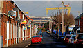
Avoniel Road, Belfast
A street of late 19th century houses off the Beersbridge Road.
Image: © Albert Bridge
Taken: 25 Jan 2010
0.05 miles
2
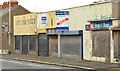
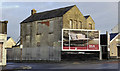
Nos 136-152 Beersbridge Road, Belfast (2)
See Image The same block of derelict shops, looking in the other direction. The Avoniel Road is second left. Continue to Image (December 2013).
Image: © Albert Bridge
Taken: 19 Dec 2011
0.07 miles
3
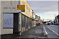
Nos 136-152 Beersbridge Road, Belfast
See Image (December 2011). A long-vacant and semi-derelict block now with a “sold” sign.
Image: © Albert Bridge
Taken: 7 Dec 2013
0.07 miles
4
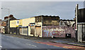
Nos 136-152 Beersbridge Road, Belfast (1)
A row of derelict shops, on the Beersbridge Road, at the corner of the Avoniel Road (right), awaiting redevelopment. Image shows the view in the other direction.
Image: © Albert Bridge
Taken: 19 Dec 2011
0.07 miles
5
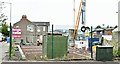
Nos 136-152 Beersbridge Road, Belfast (August 2018)
The site layout is now visible.
Image: © Albert Bridge
Taken: 18 Aug 2018
0.07 miles
6
Nos 136-152 Beersbridge Road, Belfast (April 2018)
The vacant site awaiting development. The Beersbridge Road is on the left.
Image: © Albert Bridge
Taken: 28 Apr 2018
0.07 miles
7
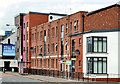
"The Sorting Office", Belfast
Apartments, on the Beersbridge Road, named after the East Belfast Sorting Office which previously occupied the site.
Image: © Albert Bridge
Taken: 15 Jul 2011
0.08 miles
8
No 154 Beersbridge Road, Belfast - April 2018(1)
A development site containing two buildings (one is out of picture to the right). This (semi derelict) seems to have been (willing to be corrected) the Beersbridge Road National School. Avoniel Road is on the left.
Image: © Albert Bridge
Taken: 28 Apr 2018
0.08 miles
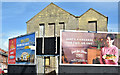
9

Coca-Cola Christmas poster, Belfast (2013)
The Coca-Cola Christmas 2013 poster on the Beersbridge Road. I’d say that it’s a fairly universal style (language excepted) and I wouldn’t be surprised to find an identical one in Belfast, Maine.
Image: © Albert Bridge
Taken: 7 Dec 2013
0.08 miles
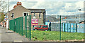
10
Derelict building, Belfast
A derelict building, off the Beersbridge Road, between the Avoniel Road Image (left) and this hall Image (right).
Image: © Albert Bridge
Taken: 19 Dec 2011
0.09 miles