IMAGES TAKEN NEAR TO
Templemore Close, BELFAST, BT5 4SY
Introduction
This page details the photographs taken nearby to Templemore Close, BT5 4SY by members of the Geograph project.
The Geograph project started in 2005 with the aim of publishing, organising and preserving representative images for every square kilometre of Great Britain, Ireland and the Isle of Man.

There are currently over 7.5m images from over14,400 individuals and you can help contribute to the project by visiting https://www.geograph.org.uk
Image Map
Images are licensed for reuse under creativecommons.org/licenses/by-sa/2.0
Notes
- Clicking on the map will re-center to the selected point.
- The higher the marker number, the further away the image location is from the centre of the postcode.
Image Listing (199 Images Found)
Images are licensed for reuse under creativecommons.org/licenses/by-sa/2.0
Image
Details
Distance
1
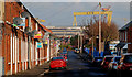
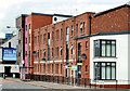
Avoniel Road, Belfast
A street of late 19th century houses off the Beersbridge Road.
Image: © Albert Bridge
Taken: 25 Jan 2010
0.04 miles
2
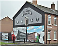
The Ledley Hall mural, Belfast (December 2017)
A mural, at the corner of Lord Street and Kingswood Street, showing the Ledley Hall http://ledleyhallboysandgirlsclub.com/. It replaced an older one which had faded badly.
Image: © Albert Bridge
Taken: 7 Dec 2017
0.07 miles
3
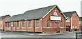
Former mission hall, Lord Street, Belfast (December 2017)
To the best of my knowledge the Belfast City Mission hall, at the corner of Haig Street (left), is now closed. If I am wrong please let me know. The mission seems to have been established here after the First World War.
Image: © Albert Bridge
Taken: 7 Dec 2017
0.08 miles
4
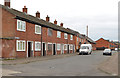
Haig Street, Belfast
An “inter-war” street running from Templemore Street (foreground) to Lord Street. The six houses on the left (the southern side) are similar to those built to replace ones damaged by the Luftwaffe (see Image). I can’t, however, find a source to confirm whether Haig Street suffered during The Blitz. Further information welcome.
Image: © Albert Bridge
Taken: 13 Nov 2013
0.09 miles
5
"The Sorting Office", Belfast
Apartments, on the Beersbridge Road, named after the East Belfast Sorting Office which previously occupied the site.
Image: © Albert Bridge
Taken: 15 Jul 2011
0.09 miles
6

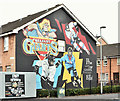
Tim Collins mural, Belfast
A mural, at Kenbaan Street, in honour of Tim Collins, http://en.wikipedia.org/wiki/Tim_Collins_(British_Army_officer) , a former colonel in the Royal Irish Regiment, best known for his speech before the invasion of Iraq http://www.youtube.com/watch?v=pKkILSv54OU. An actor appears in the link.
Image: © Albert Bridge
Taken: 7 Dec 2013
0.09 miles
7
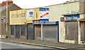
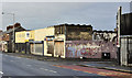
Nos 136-152 Beersbridge Road, Belfast (2)
See Image The same block of derelict shops, looking in the other direction. The Avoniel Road is second left. Continue to Image (December 2013).
Image: © Albert Bridge
Taken: 19 Dec 2011
0.10 miles
8
Nos 136-152 Beersbridge Road, Belfast
See Image (December 2011). A long-vacant and semi-derelict block now with a “sold” sign.
Image: © Albert Bridge
Taken: 7 Dec 2013
0.10 miles
9
Belfast Giants mural, Belfast - October 2016(1)
A Belfast Giants https://en.wikipedia.org/wiki/Belfast_Giants ice hockey team mural at Lord Street/Edith Street. It replaced this Image See also Image
Image: © Albert Bridge
Taken: 22 Oct 2016
0.10 miles
10
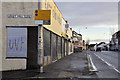
Nos 136-152 Beersbridge Road, Belfast (1)
A row of derelict shops, on the Beersbridge Road, at the corner of the Avoniel Road (right), awaiting redevelopment. Image shows the view in the other direction.
Image: © Albert Bridge
Taken: 19 Dec 2011
0.10 miles