IMAGES TAKEN NEAR TO
Madrid Court, BELFAST, BT5 4SX
Introduction
This page details the photographs taken nearby to Madrid Court, BT5 4SX by members of the Geograph project.
The Geograph project started in 2005 with the aim of publishing, organising and preserving representative images for every square kilometre of Great Britain, Ireland and the Isle of Man.

There are currently over 7.5m images from over14,400 individuals and you can help contribute to the project by visiting https://www.geograph.org.uk
Image Map
Images are licensed for reuse under creativecommons.org/licenses/by-sa/2.0
Notes
- Clicking on the map will re-center to the selected point.
- The higher the marker number, the further away the image location is from the centre of the postcode.
Image Listing (228 Images Found)
Images are licensed for reuse under creativecommons.org/licenses/by-sa/2.0
Image
Details
Distance
1
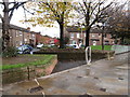
Houses in the Catholic enclave of Short Strand, Inner East Belfast
The Short Strand is a Catholic enclave in the predominantly Protestant Inner East Belfast and its interfaces are the scene of frequent clashes between the two communities. It has a population of around 2,300 living in some 1040 households.
http://research.shu.ac.uk/cresr/recession-resilience-rebalancing/east-belfast.htm
Image: © Eric Jones
Taken: 3 Nov 2014
0.02 miles
2
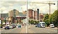
The Albertbridge Road, Belfast
Part of the route, from much of suburban east Belfast, to the city centre. The Albert Bridge Image is at lower left (just right of the bus). The Laganside developments make up most of the background. Pottingers Quay Image is the red-brick building to the right of the lampposts (middle).
Image: © Albert Bridge
Taken: 22 Jul 2009
0.04 miles
3
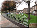
Short Strand Estate
The Short Strand is a Catholic enclave in predominantly Portestant Inner East Belfast and its interfaces are the scene of frequent clashes between the two communities. It has a population of around 2,300 living in some 1040 households.
http://research.shu.ac.uk/cresr/recession-resilience-rebalancing/east-belfast.htm
Image: © Eric Jones
Taken: 3 Nov 2014
0.04 miles
4

Bus lane, Albertbridge Road (EWAY) - June 2014(2)
See Image The bus lane being used by two inward Metro buses.
Image: © Albert Bridge
Taken: 9 Jun 2014
0.05 miles
5
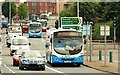
Four buses, Belfast
Four buses (on four different routes), make their way along the Albertbridge Road Image, from Co Down and suburban east Belfast.
Image: © Albert Bridge
Taken: 22 Jul 2009
0.06 miles
6
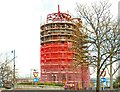
Pottinger's Quay, Belfast (5)
See Image There has been substantial progress in the four months since the last photo. The new brickwork is partly concealed behind the safety mesh. Continue to Image
Image: © Albert Bridge
Taken: 12 Apr 2009
0.06 miles
7
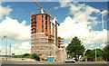
Pottingers Quay, Belfast (7)
See Image At last – a decent view of the building now that much of the scaffolding and safety mesh has been removed. Continue to Image
Image: © Albert Bridge
Taken: 22 Jul 2009
0.06 miles
8
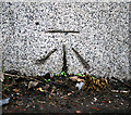
Bench Mark, Belfast
Cut bench mark located on the extreme north-eastern tip of the Albert Bridge in Belfast Image
The mark is 4.92 metres above MSL.
See also http://www.geograph.org.uk/search.php?i=11037856 for many other examples I have found.
Image: © Rossographer
Taken: 31 Mar 2010
0.06 miles
9
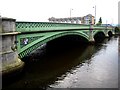
Albert Bridge
The Albert Bridge over the river Lagan
Image: © Rossographer
Taken: 18 Jun 2007
0.06 miles
10
![Albert Bridge [2]](https://s3.geograph.org.uk/photos/47/03/470367_0ee5a921_120x120.jpg)
Albert Bridge [2]
Detail on the Albert Bridge over the river Lagan
Image: © Rossographer
Taken: 18 Jun 2007
0.06 miles