IMAGES TAKEN NEAR TO
Beersbridge Road, BELFAST, BT5 4RR
Introduction
This page details the photographs taken nearby to Beersbridge Road, BT5 4RR by members of the Geograph project.
The Geograph project started in 2005 with the aim of publishing, organising and preserving representative images for every square kilometre of Great Britain, Ireland and the Isle of Man.

There are currently over 7.5m images from over14,400 individuals and you can help contribute to the project by visiting https://www.geograph.org.uk
Image Map
Images are licensed for reuse under creativecommons.org/licenses/by-sa/2.0
Notes
- Clicking on the map will re-center to the selected point.
- The higher the marker number, the further away the image location is from the centre of the postcode.
Image Listing (123 Images Found)
Images are licensed for reuse under creativecommons.org/licenses/by-sa/2.0
Image
Details
Distance
1
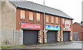
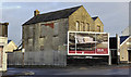
Nos 167 - 177 Beersbridge Road, Belfast (December 2015)
A row of vacant shops which were to have been auctioned, as three lots, on 19 March 2015. The agents’ website refers to the middle one as “Unsold. Please refer to Auctioneer. Prominent mid terrace retail property Comprising a retail unit with office accommodation above Extending to approximately 825 sq ft (76.6 sq m) Ideal owner occupier or investor purchase”. This photograph appears as a matter of record only. I have no connection with any of the parties involved in the sale.
Image: © Albert Bridge
Taken: 14 Dec 2015
0.00 miles
2
Nos 179-181 Beersbridge Road, Belfast (December 2017)
Three vacant properties which had the following planning permission (23 September 2009) “Z/2008/0014/F 18 No. Apartments, car parking, and associated site works. 179/181 Beersbridge Road, Ballymacarret, Belfast, BT05 4RR”. The site of nos 183-191 Image is on the left.
Image: © Albert Bridge
Taken: 7 Dec 2017
0.00 miles
3

Coca-Cola Christmas poster, Belfast (2013)
The Coca-Cola Christmas 2013 poster on the Beersbridge Road. I’d say that it’s a fairly universal style (language excepted) and I wouldn’t be surprised to find an identical one in Belfast, Maine.
Image: © Albert Bridge
Taken: 7 Dec 2013
0.01 miles
4
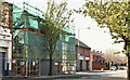
Nos 183-191 Beersbridge Road, Belfast (April 2019)
The apartments, under construction and well hidden by shadow, scaffolding and mesh.
Image: © Albert Bridge
Taken: 22 Apr 2019
0.01 miles
5
Nos 136-152 Beersbridge Road, Belfast (April 2018)
The vacant site awaiting development. The Beersbridge Road is on the left.
Image: © Albert Bridge
Taken: 28 Apr 2018
0.01 miles
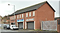
6
Derelict building, Belfast
A derelict building, off the Beersbridge Road, between the Avoniel Road Image (left) and this hall Image (right).
Image: © Albert Bridge
Taken: 19 Dec 2011
0.01 miles
7
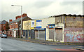
Nos 136-152 Beersbridge Road, Belfast (3)
See Image (December 2011). The buildings now have a “for sale” sign. Described by the agents as “Suitable for a number of residential / commercial uses (Subject to planning permission)”. This photograph appears as a matter of record only. I have no connection with any of the parties involved in the sale.
Image: © Albert Bridge
Taken: 17 Oct 2012
0.01 miles
8
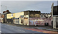
Nos 136-152 Beersbridge Road, Belfast (1)
A row of derelict shops, on the Beersbridge Road, at the corner of the Avoniel Road (right), awaiting redevelopment. Image shows the view in the other direction.
Image: © Albert Bridge
Taken: 19 Dec 2011
0.02 miles
9
Nos 136-152 Beersbridge Road, Belfast (August 2018)
The site layout is now visible.
Image: © Albert Bridge
Taken: 18 Aug 2018
0.02 miles
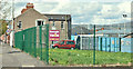
10

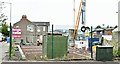
No 154 Beersbridge Road, Belfast - April 2018(1)
A development site containing two buildings (one is out of picture to the right). This (semi derelict) seems to have been (willing to be corrected) the Beersbridge Road National School. Avoniel Road is on the left.
Image: © Albert Bridge
Taken: 28 Apr 2018
0.02 miles