1
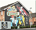
The Ledley Hall mural, Belfast (December 2017)
A mural, at the corner of Lord Street and Kingswood Street, showing the Ledley Hall http://ledleyhallboysandgirlsclub.com/. It replaced an older one which had faded badly.
Image: © Albert Bridge
Taken: 7 Dec 2017
0.02 miles
2
Epworth Street, Belfast
A street, built before 1901, running from Lord Street to Templemore Avenue (background) and now rebuilt in two completely different architectural styles.
Image: © Albert Bridge
Taken: 13 Nov 2013
0.03 miles
3
Former mission hall, Lord Street, Belfast (December 2017)
To the best of my knowledge the Belfast City Mission hall, at the corner of Haig Street (left), is now closed. If I am wrong please let me know. The mission seems to have been established here after the First World War.
Image: © Albert Bridge
Taken: 7 Dec 2017
0.04 miles
4
Belfast Giants mural, Belfast - October 2016(2)
See
Image Another part of the same mural – depicting a stick and puck. It replaced
Image
Image: © Albert Bridge
Taken: 22 Oct 2016
0.05 miles
5
Belfast Giants mural, Belfast - October 2016(1)
A Belfast Giants https://en.wikipedia.org/wiki/Belfast_Giants ice hockey team mural at Lord Street/Edith Street. It replaced this
Image See also
Image
Image: © Albert Bridge
Taken: 22 Oct 2016
0.05 miles
6
Apartments in Lord Street
Image: © Eric Jones
Taken: 3 Nov 2014
0.06 miles
7
Paxton Street, Belfast (1)
The 1877 street directory shows Paxton Street, with 20 odd-numbered houses, running off Templemore Park but there is no Templemore Park shown as a street in its own right. The 1901 edition shows it, with 62 houses, running from Castlereagh Street, via Templemore Avenue, to Lord Street. Templemore Avenue is shown with only five houses in 1877. The 6 inch map (undated) on the OSI site shows the general area as fields with a few mills. There is a James Kelly
Image shown as living at no 21 in 1877.
This photograph, from Templemore Avenue, shows the rebuilt part between it and Lord Street.
Image shows the view from Castlereagh Street.
Image: © Albert Bridge
Taken: 13 Nov 2013
0.07 miles
8
Haig Street, Belfast
An “inter-war” street running from Templemore Street (foreground) to Lord Street. The six houses on the left (the southern side) are similar to those built to replace ones damaged by the Luftwaffe (see
Image). I can’t, however, find a source to confirm whether Haig Street suffered during The Blitz. Further information welcome.
Image: © Albert Bridge
Taken: 13 Nov 2013
0.08 miles
9
Tim Collins mural, Belfast
A mural, at Kenbaan Street, in honour of Tim Collins, http://en.wikipedia.org/wiki/Tim_Collins_(British_Army_officer) , a former colonel in the Royal Irish Regiment, best known for his speech before the invasion of Iraq http://www.youtube.com/watch?v=pKkILSv54OU. An actor appears in the link.
Image: © Albert Bridge
Taken: 7 Dec 2013
0.08 miles
10
Chatsworth Street, Belfast (October 2016)
See
Image and
Image (both November 2013). Chatsworth Street from Lord Street. Redeveloped in the same style.
Image: © Albert Bridge
Taken: 22 Oct 2016
0.08 miles


