IMAGES TAKEN NEAR TO
Paxton Street, BELFAST, BT5 4QN
Introduction
This page details the photographs taken nearby to Paxton Street, BT5 4QN by members of the Geograph project.
The Geograph project started in 2005 with the aim of publishing, organising and preserving representative images for every square kilometre of Great Britain, Ireland and the Isle of Man.

There are currently over 7.5m images from over14,400 individuals and you can help contribute to the project by visiting https://www.geograph.org.uk
Image Map
Images are licensed for reuse under creativecommons.org/licenses/by-sa/2.0
Notes
- Clicking on the map will re-center to the selected point.
- The higher the marker number, the further away the image location is from the centre of the postcode.
Image Listing (252 Images Found)
Images are licensed for reuse under creativecommons.org/licenses/by-sa/2.0
Image
Details
Distance
1
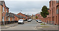
Epworth Street, Belfast
A street, built before 1901, running from Lord Street to Templemore Avenue (background) and now rebuilt in two completely different architectural styles.
Image: © Albert Bridge
Taken: 13 Nov 2013
0.02 miles
3
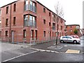
Paxton Street, Belfast (1)
The 1877 street directory shows Paxton Street, with 20 odd-numbered houses, running off Templemore Park but there is no Templemore Park shown as a street in its own right. The 1901 edition shows it, with 62 houses, running from Castlereagh Street, via Templemore Avenue, to Lord Street. Templemore Avenue is shown with only five houses in 1877. The 6 inch map (undated) on the OSI site shows the general area as fields with a few mills. There is a James Kelly Image shown as living at no 21 in 1877.
This photograph, from Templemore Avenue, shows the rebuilt part between it and Lord Street. Image shows the view from Castlereagh Street.
Image: © Albert Bridge
Taken: 13 Nov 2013
0.03 miles
4
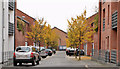
Chatsworth Street, Belfast (October 2016)
See Image and Image (both November 2013). Chatsworth Street from Lord Street. Redeveloped in the same style.
Image: © Albert Bridge
Taken: 22 Oct 2016
0.04 miles
5
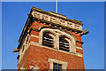
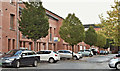
St Clement's (CoI) parish church, Belfast (1)
In Templemore Avenue (the bit between the Albertbridge Road and Castlereagh Street). Built in 1928/30, to a design by PM Jury of Blackwood and Jury, using Buckley (Flint) bricks - an alien brick which does not clash with the Belfast brick used in many of the surrounding streets. Parked cars make the entire church hard to photograph. This is the tower. continue to Image
Image: © Albert Bridge
Taken: 25 Jan 2010
0.04 miles
6
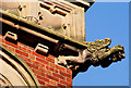
St Clement's (CoI) parish church, Belfast (2)
See Image One of the church’s gargoyles (ears covered to mask the din of the passing traffic) by S&T Hastings of Downpatrick.
Image: © Albert Bridge
Taken: 25 Jan 2010
0.04 miles
7
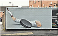
Belfast Giants mural, Belfast - October 2016(2)
Image: © Albert Bridge
Taken: 22 Oct 2016
0.04 miles
8
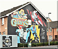
Belfast Giants mural, Belfast - October 2016(1)
A Belfast Giants https://en.wikipedia.org/wiki/Belfast_Giants ice hockey team mural at Lord Street/Edith Street. It replaced this Image See also Image
Image: © Albert Bridge
Taken: 22 Oct 2016
0.05 miles
9
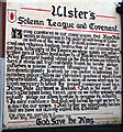
'Ulster Covenant' mural, Thorndyke Street, Belfast
Mural reproducing the Ulster Covenant in Thorndyke Street, Belfast.
The Ulster Covenant was signed by just under half a million of men and women from Ulster, Ireland, on and before September 28, 1912, in protest of a Home Rule bill introduced by the British Government in that same year. Sir Edward Carson (see Image and Image) was the first person to sign the Covenant at the Belfast City Hall. The signers were all unionists, who were against the establishment of an Irish parliament in Dublin. Some even signed in their own blood to show their dedication to the cause. The Ulster Covenant is immortalised in Rudyard Kipling's poem "Ulster 1912". See http://en.wikipedia.org/wiki/Ulster_Covenant for more information.
Image: © Rossographer
Taken: 10 Jul 2008
0.05 miles
10
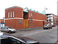
Iron Hall, Templemore Street, Ballymacarret
This evangelical church traces its origins back to a tin roofed mission hall built in 1890 at the corner of Thorndyke Street, off Templemore Avenue. That building was destroyed in the Blitz of 1941 which killed almost a thousand people and damaged fifty thousand houses - some 50% of the total. The new purpose-built Iron Hall dates from 2004.
Image: © Eric Jones
Taken: 3 Nov 2014
0.05 miles